Pölich geodata
Pölich (Rheinland-Pfalz) is a seat of a fourth-order administrative division; located in Germany in Europe/Berlin (GMT+2) time zone. With population of 379 people, there are 9759 cities with bigger population in this country. Compared to other cities in Germany, 69% of cities are located further ↑North; 95.1% of cities are located further →East and 64.5% of cities have higher elevation than Pölich. Note1
Administrative division(s):
- Level 1: Rheinland-Pfalz
- Level 3: Landkreis Trier-Saarburg
- Level 4: Pölich


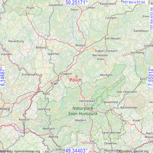
Pölich GPS coordinates[2]
49° 48' 0" North, 6° 51' 0" East
| Map corner | latitude | longitude |
|---|---|---|
| Upper-left | 50.25171°, | 6.14687° |
| Center: | 49.8°, | 6.85° |
| Lower-right: | 49.34403°, | 7.55312° |
| Map W x H: | 100.9×100.9 km | = 62.7×62.7mi |
| max Lat: | 55.01917° ⇑69% North |
| Pölich: | 49.8° |
| min Lat: | ⇓31% South 47.40724° |
| min Long | Pölich | max Long |
| 5.92978° | 6.85° | 14.98853° |
| W 4.9%⇐ | ⇒95.1% E |
Elevation
Elevation of Pölich is 124 m = 407 ft, and this is 125.1 m = 410 ft below average elevation for this country.
| Max E: |
1256 m = 4121 ft | 64.5% |
| Avg. | 249.1 m = 817 ft | |
| Pölich | 124 m = 407 ft | |
Min E: |
-5 m = -16 ft | 35.5% |
See also: Germany elevation on elevation.city.
Geographical zone
Pölich is located in North temperate zone (between Tropic of Cancer and the Arctic Circle). Distance of this North polar circle is 1863.9 km =1158.2 mi to North.| Distance of | km | miles | from Pölich |
|---|---|---|---|
| North Pole | 4469.8 | 2777.4 | to North |
| Arctic Circle | 1863.9 | 1158.2 | to North |
| Tropic Cancer | 2931.3 | 1821.4 | to South |
| Equator | 5537.2 | 3440.7 | to South |


Nearby cities:
15 places around Pölich: (largest is in red/bold)
• Breit
4.8 km =3 mi,  124°
124°
• Büdlich
4 km =2.5 mi, 117°
• Detzem
1.9 km =1.2 mi,  0°
0°
• Ensch
3.3 km =2.1 mi,  337°
337°
• Heidenburg
4.8 km =3 mi,  90°
90°
• Klüsserath
5 km =3.1 mi, 0°
• Köwerich
4.4 km =2.7 mi,  32°
32°
• Leiwen
3 km =1.9 mi,  52°
52°
• Longen
4.8 km =3 mi,  270°
270°
• Longuich
5.9 km =3.7 mi,  279°
279°
• Mehring
1.2 km =0.7 mi, 270°
• Riol
4.2 km =2.6 mi,  259°
259°
• Schleich
2.2 km =1.4 mi,  327°
327°
• Thörnich
3.9 km =2.4 mi,  347°
347°
• Trittenheim
4.5 km =2.8 mi, 52°
Sources, notices
• [Note1] Compared only with cities in Germany existing in our database
• [Src1] Map data: © OpenStreetMap contributors (CC-BY-SA)
• [Src2] Other city data from geonames.org with taken over terms of usage.
• [Src3] Geographical zone / Annual Mean Temperature by Robert A. Rohde @ Wikipedia
