Heidenburg geodata
Heidenburg (Rheinland-Pfalz) is a seat of a fourth-order administrative division; located in Germany in Europe/Berlin (GMT+2) time zone. With population of 724 people, there are 8220 cities with bigger population in this country. Compared to other cities in Germany, 69% of cities are located further ↑North; 94.4% of cities are located further →East and 75.1% of cities have lower elevation than Heidenburg. Note1
Administrative division(s):
- Level 1: Rheinland-Pfalz
- Level 3: Landkreis Bernkastel-Wittlich
- Level 4: Heidenburg


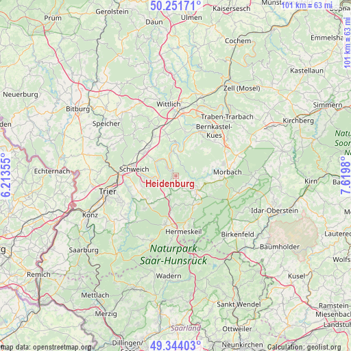
Heidenburg GPS coordinates[2]
49° 48' 0" North, 6° 55' 0.012" East
| Map corner | latitude | longitude |
|---|---|---|
| Upper-left | 50.25171°, | 6.21355° |
| Center: | 49.8°, | 6.91667° |
| Lower-right: | 49.34403°, | 7.6198° |
| Map W x H: | 100.9×100.9 km | = 62.7×62.7mi |
| max Lat: | 55.01917° ⇑69% North |
| Heidenburg: | 49.8° |
| min Lat: | ⇓31% South 47.40724° |
| min Long | Heidenburg | max Long |
| 5.92978° | 6.91667° | 14.98853° |
| W 5.6%⇐ | ⇒94.4% E |
Elevation
Elevation of Heidenburg is 398 m = 1306 ft, and this is 148.9 m = 489 ft above average elevation for this country.
| Max E: |
1256 m = 4121 ft | 24.9% |
| Heidenburg | 398 m 1306 ft | |
| Avg. | 249.1 m = 817 ft | |
Min E: |
-5 m = -16 ft | 75.1% |
See also: Germany elevation on elevation.city.
Geographical zone
Heidenburg is located in North temperate zone (between Tropic of Cancer and the Arctic Circle). Distance of this North polar circle is 1863.9 km =1158.2 mi to North.| Distance of | km | miles | from Heidenburg |
|---|---|---|---|
| North Pole | 4469.8 | 2777.4 | to North |
| Arctic Circle | 1863.9 | 1158.2 | to North |
| Tropic Cancer | 2931.3 | 1821.4 | to South |
| Equator | 5537.2 | 3440.7 | to South |


Nearby cities:
15 places around Heidenburg: (largest is in red/bold)
• Berglicht
3.8 km =2.4 mi,  111°
111°
• Breit
2.8 km =1.7 mi,  196°
196°
• Büdlich
2.2 km =1.4 mi,  212°
212°
• Detzem
5.1 km =3.2 mi,  291°
291°
• Gräfendhron
5.5 km =3.4 mi,  96°
96°
• Horath
5.1 km =3.2 mi,  76°
76°
• Köwerich
4.4 km =2.7 mi,  327°
327°
• Leiwen
3 km =1.9 mi,  307°
307°
• Mehring
6 km =3.7 mi,  270°
270°
• Merschbach
6 km =3.7 mi,  90°
90°
• Neunkirchen
6.1 km =3.8 mi,  156°
156°
• Pölich
4.8 km =3 mi, 270°
• Schönberg
3.7 km =2.3 mi,  180°
180°
• Talling
4.4 km =2.7 mi,  147°
147°
• Trittenheim
3 km =1.9 mi,  335°
335°
Sources, notices
• [Note1] Compared only with cities in Germany existing in our database
• [Src1] Map data: © OpenStreetMap contributors (CC-BY-SA)
• [Src2] Other city data from geonames.org with taken over terms of usage.
• [Src3] Geographical zone / Annual Mean Temperature by Robert A. Rohde @ Wikipedia
