Pellworm geodata
Pellworm (Schleswig-Holstein) is a seat of a fourth-order administrative division; located in Germany in Europe/Berlin (GMT+2) time zone. With population of 1,152 people, there are 6696 cities with bigger population in this country. Compared to other cities in Germany, 98.1% of cities are located further ↓South; 69.7% of cities are located further →East and 99.5% of cities have higher elevation than Pellworm. Note1
Administrative division(s):
- Level 1: Schleswig-Holstein
- Level 3: Kreis Nordfriesland
- Level 4: Pellworm


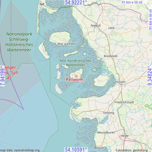
Pellworm GPS coordinates[2]
54° 30' 57.96" North, 8° 38' 42.432" East
| Map corner | latitude | longitude |
|---|---|---|
| Upper-left | 54.92221°, | 7.94199° |
| Center: | 54.5161°, | 8.64512° |
| Lower-right: | 54.10591°, | 9.34824° |
| Map W x H: | 90.8×90.8 km | = 56.4×56.4mi |
| max Lat: | 55.01917° ⇑1.9% North |
| Pellworm: | 54.5161° |
| min Lat: | ⇓98.1% South 47.40724° |
| min Long | Pellworm | max Long |
| 5.92978° | 8.64512° | 14.98853° |
| W 30.3%⇐ | ⇒69.7% E |
Elevation
Elevation of Pellworm is -1 m = -3 ft, and this is 250.1 m = 821 ft below average elevation for this country.
| Max E: |
1256 m = 4121 ft | 99.5% |
| Avg. | 249.1 m = 817 ft | |
| Pellworm | -1 m = -3 ft | |
Min E: |
-5 m = -16 ft | 0.5% |
See also: Germany elevation on elevation.city.
Geographical zone
Pellworm is located in North temperate zone (between Tropic of Cancer and the Arctic Circle). Distance of this North polar circle is 1339.6 km =832.4 mi to North.| Distance of | km | miles | from Pellworm |
|---|---|---|---|
| North Pole | 3945.4 | 2451.6 | to North |
| Arctic Circle | 1339.6 | 832.4 | to North |
| Tropic Cancer | 3455.7 | 2147.3 | to South |
| Equator | 6061.6 | 3766.5 | to South |


Nearby cities:
15 places around Pellworm: (largest is in red/bold)
• Elisabeth-Sophien-Koog
15.4 km =9.6 mi,  89°
89°
• Gröde
13.8 km =8.6 mi,  19°
19°
• Hooge
8.7 km =5.4 mi,  313°
313°
• Langeneß
14.2 km =8.8 mi,  346°
346°
• Ockholm
20.7 km =12.9 mi,  35°
35°
• Osterhever
16.5 km =10.3 mi,  151°
151°
• Poppenbüll
18.8 km =11.7 mi,  156°
156°
• Reußenköge
19.2 km =11.9 mi,  60°
60°
• Tating
21.5 km =13.4 mi,  169°
169°
• Tümlauer Koog
18.6 km =11.6 mi, 172°
• Uelvesbüll
21.2 km =13.2 mi,  121°
121°
• Westerhever
15 km =9.3 mi, 172°
• Wittdün
20.6 km =12.8 mi, 306°
• Wrixum
21.4 km =13.3 mi,  343°
343°
• Wyk auf Föhr
20.1 km =12.5 mi, 345°
Sources, notices
• [Note1] Compared only with cities in Germany existing in our database
• [Src1] Map data: © OpenStreetMap contributors (CC-BY-SA)
• [Src2] Other city data from geonames.org with taken over terms of usage.
• [Src3] Geographical zone / Annual Mean Temperature by Robert A. Rohde @ Wikipedia
