Gröde geodata
Gröde (Schleswig-Holstein) is a seat of a fourth-order administrative division; located in Germany in Europe/Berlin (GMT+2) time zone. With population of 15 people, there are 11007 cities with bigger population in this country. Compared to other cities in Germany, 98.8% of cities are located further ↓South; 68.9% of cities are located further →East and 99.8% of cities have higher elevation than Gröde. Note1


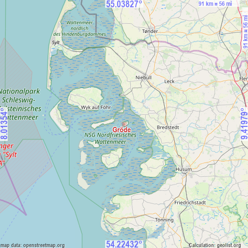
Gröde GPS coordinates[2]
54° 37' 59.988" North, 8° 43' 0.012" East
| Map corner | latitude | longitude |
|---|---|---|
| Upper-left | 55.03827°, | 8.01354° |
| Center: | 54.63333°, | 8.71667° |
| Lower-right: | 54.22432°, | 9.41979° |
| Map W x H: | 90.5×90.5 km | = 56.2×56.2mi |
| max Lat: | 55.01917° ⇑1.2% North |
| Gröde: | 54.63333° |
| min Lat: | ⇓98.8% South 47.40724° |
| min Long | Gröde | max Long |
| 5.92978° | 8.71667° | 14.98853° |
| W 31.1%⇐ | ⇒68.9% E |
Elevation
Elevation of Gröde is -2 m = -7 ft, and this is 251.1 m = 824 ft below average elevation for this country.
| Max E: |
1256 m = 4121 ft | 99.8% |
| Avg. | 249.1 m = 817 ft | |
| Gröde | -2 m = -7 ft | |
Min E: |
-5 m = -16 ft | 0.2% |
See also: Germany elevation on elevation.city.
Geographical zone
Gröde is located in North temperate zone (between Tropic of Cancer and the Arctic Circle). Distance of this North polar circle is 1326.5 km =824.2 mi to North.| Distance of | km | miles | from Gröde |
|---|---|---|---|
| North Pole | 3932.4 | 2443.5 | to North |
| Arctic Circle | 1326.5 | 824.2 | to North |
| Tropic Cancer | 3468.7 | 2155.3 | to South |
| Equator | 6074.7 | 3774.6 | to South |


Nearby cities:
15 places around Gröde: (largest is in red/bold)
• Alkersum
15.7 km =9.8 mi,  301°
301°
• Bordelum
13.9 km =8.6 mi,  90°
90°
• Dagebüll
10.7 km =6.6 mi,  354°
354°
• Galmsbüll
13.1 km =8.1 mi,  9°
9°
• Hooge
12.9 km =8 mi,  237°
237°
• Langeneß
8.1 km =5 mi,  275°
275°
• Langenhorn
13.4 km =8.3 mi,  73°
73°
• Midlum
15.5 km =9.6 mi,  305°
305°
• Nieblum
15.9 km =9.9 mi,  294°
294°
• Ockholm
8.4 km =5.2 mi,  63°
63°
• Oevenum
14.6 km =9.1 mi, 305°
• Pellworm
13.8 km =8.6 mi,  199°
199°
• Reußenköge
12.5 km =7.8 mi,  106°
106°
• Wrixum
13.1 km =8.1 mi, 304°
• Wyk auf Föhr
11.6 km =7.2 mi, 303°
Sources, notices
• [Note1] Compared only with cities in Germany existing in our database
• [Src1] Map data: © OpenStreetMap contributors (CC-BY-SA)
• [Src2] Other city data from geonames.org with taken over terms of usage.
• [Src3] Geographical zone / Annual Mean Temperature by Robert A. Rohde @ Wikipedia
