Oschersleben geodata
Oschersleben (Saxony-Anhalt) is a populated place; located in Germany in Europe/Berlin (GMT+2) time zone. With population of 17,900 people, there are 885 cities with bigger population in this country. Compared to other cities in Germany, 72.3% of cities are located further ↓South; 70.3% of cities are located further ←West and 71.3% of cities have higher elevation than Oschersleben. Note1


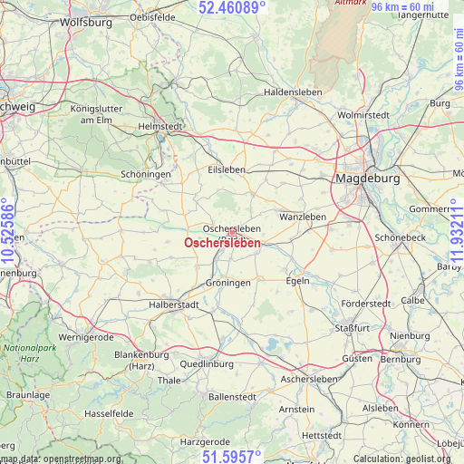
Oschersleben GPS coordinates[2]
52° 1' 49.404" North, 11° 13' 44.328" East
| Map corner | latitude | longitude |
|---|---|---|
| Upper-left | 52.46089°, | 10.52586° |
| Center: | 52.03039°, | 11.22898° |
| Lower-right: | 51.5957°, | 11.93211° |
| Map W x H: | 96.2×96.2 km | = 59.8×59.8mi |
| max Lat: | 55.01917° ⇑27.7% North |
| Oschersleben: | 52.03039° |
| min Lat: | ⇓72.3% South 47.40724° |
| min Long | Oschersleben | max Long |
| 5.92978° | 11.22898° | 14.98853° |
| W 70.3%⇐ | ⇒29.7% E |
Elevation
Elevation of Oschersleben is 82 m = 269 ft, and this is 167.1 m = 548 ft below average elevation for this country.
| Max E: |
1256 m = 4121 ft | 71.3% |
| Avg. | 249.1 m = 817 ft | |
| Oschersleben | 82 m = 269 ft | |
Min E: |
-5 m = -16 ft | 28.7% |
See also: Germany elevation on elevation.city.
Geographical zone
Oschersleben is located in North temperate zone (between Tropic of Cancer and the Arctic Circle). Distance of this North polar circle is 1615.9 km =1004.1 mi to North.| Distance of | km | miles | from Oschersleben |
|---|---|---|---|
| North Pole | 4221.8 | 2623.3 | to North |
| Arctic Circle | 1615.9 | 1004.1 | to North |
| Tropic Cancer | 3179.3 | 1975.5 | to South |
| Equator | 5785.2 | 3594.8 | to South |


Nearby cities:
15 places around Oschersleben: (largest is in red/bold)
• Ausleben
10.4 km =6.5 mi,  309°
309°
• Dreileben
12.9 km =8 mi,  32°
32°
• Eilsleben
13 km =8.1 mi,  354°
354°
• Groß Quenstedt
13.3 km =8.3 mi,  215°
215°
• Gröningen
10.4 km =6.5 mi,  184°
184°
• Hadmersleben
6.6 km =4.1 mi,  129°
129°
• Hamersleben
10.5 km =6.5 mi,  290°
290°
• Hornhausen
4.3 km =2.7 mi, 292°
• Klein Wanzleben
10.4 km =6.5 mi,  64°
64°
• Kroppenstedt
11.2 km =7 mi,  151°
151°
• Schermcke
5 km =3.1 mi,  52°
52°
• Schwanebeck
10 km =6.2 mi,  225°
225°
• Seehausen
9.1 km =5.7 mi, 27°
• Wormsdorf
11.7 km =7.3 mi, 348°
• Wulferstedt
6.8 km =4.2 mi,  259°
259°
Sources, notices
• [Note1] Compared only with cities in Germany existing in our database
• [Src1] Map data: © OpenStreetMap contributors (CC-BY-SA)
• [Src2] Other city data from geonames.org with taken over terms of usage.
• [Src3] Geographical zone / Annual Mean Temperature by Robert A. Rohde @ Wikipedia
