Hornhausen geodata
Hornhausen (Saxony-Anhalt) is a populated place; located in Germany in Europe/Berlin (GMT+2) time zone. With population of 1,716 people, there are 5486 cities with bigger population in this country. Compared to other cities in Germany, 72.5% of cities are located further ↓South; 69.5% of cities are located further ←West and 71% of cities have higher elevation than Hornhausen. Note1


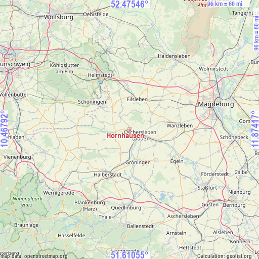
Hornhausen GPS coordinates[2]
52° 2' 42.36" North, 11° 10' 15.744" East
| Map corner | latitude | longitude |
|---|---|---|
| Upper-left | 52.47546°, | 10.46792° |
| Center: | 52.0451°, | 11.17104° |
| Lower-right: | 51.61055°, | 11.87417° |
| Map W x H: | 96.2×96.2 km | = 59.8×59.8mi |
| max Lat: | 55.01917° ⇑27.5% North |
| Hornhausen: | 52.0451° |
| min Lat: | ⇓72.5% South 47.40724° |
| min Long | Hornhausen | max Long |
| 5.92978° | 11.17104° | 14.98853° |
| W 69.5%⇐ | ⇒30.5% E |
Elevation
Elevation of Hornhausen is 85 m = 279 ft, and this is 164.1 m = 538 ft below average elevation for this country.
| Max E: |
1256 m = 4121 ft | 71% |
| Avg. | 249.1 m = 817 ft | |
| Hornhausen | 85 m = 279 ft | |
Min E: |
-5 m = -16 ft | 29% |
See also: Germany elevation on elevation.city.
Geographical zone
Hornhausen is located in North temperate zone (between Tropic of Cancer and the Arctic Circle). Distance of this North polar circle is 1614.3 km =1003.1 mi to North.| Distance of | km | miles | from Hornhausen |
|---|---|---|---|
| North Pole | 4220.2 | 2622.3 | to North |
| Arctic Circle | 1614.3 | 1003.1 | to North |
| Tropic Cancer | 3181 | 1976.6 | to South |
| Equator | 5786.9 | 3595.8 | to South |


Nearby cities:
15 places around Hornhausen: (largest is in red/bold)
• Ausleben
6.5 km =4 mi,  321°
321°
• Barneberg
10.7 km =6.6 mi, 322°
• Eilsleben
11.7 km =7.3 mi,  13°
13°
• Gröningen
12.4 km =7.7 mi,  165°
165°
• Hadmersleben
10.7 km =6.6 mi,  122°
122°
• Hamersleben
6.2 km =3.9 mi,  288°
288°
• Oschersleben
4.3 km =2.7 mi,  112°
112°
• Schermcke
8 km =5 mi,  80°
80°
• Schwanebeck
9.2 km =5.7 mi,  200°
200°
• Seehausen
10.4 km =6.5 mi,  52°
52°
• Ummendorf
12.4 km =7.7 mi,  3°
3°
• Völpke
11.5 km =7.1 mi,  334°
334°
• Wackersleben
10.8 km =6.7 mi,  284°
284°
• Wormsdorf
10 km =6.2 mi, 8°
• Wulferstedt
3.9 km =2.4 mi,  223°
223°
Sources, notices
• [Note1] Compared only with cities in Germany existing in our database
• [Src1] Map data: © OpenStreetMap contributors (CC-BY-SA)
• [Src2] Other city data from geonames.org with taken over terms of usage.
• [Src3] Geographical zone / Annual Mean Temperature by Robert A. Rohde @ Wikipedia
