Gröningen geodata
Gröningen (Saxony-Anhalt) is a seat of a fourth-order administrative division; located in Germany in Europe/Berlin (GMT+2) time zone. With population of 4,166 people, there are 3191 cities with bigger population in this country. Compared to other cities in Germany, 71.5% of cities are located further ↓South; 70.2% of cities are located further ←West and 69.8% of cities have higher elevation than Gröningen. Note1


Gröningen GPS coordinates[2]
51° 56' 14.784" North, 11° 12' 57.636" East
| Map corner | latitude | longitude |
|---|---|---|
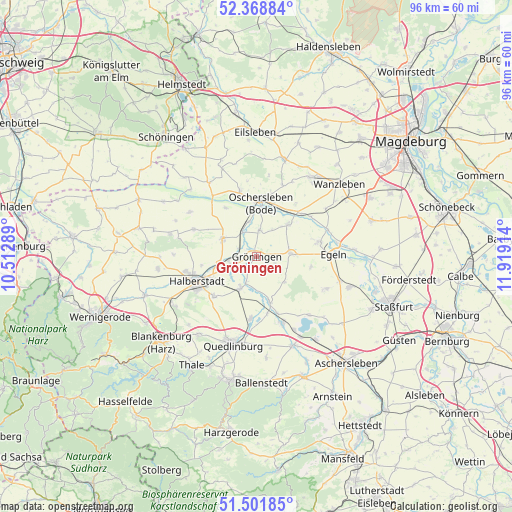
| Upper-left | 52.36884°, | 10.51289° |
| Center: | 51.93744°, | 11.21601° |
| Lower-right: | 51.50185°, | 11.91914° |
| Map W x H: | 96.4×96.4 km | = 59.9×59.9mi |
| max Lat: | 55.01917° ⇑28.5% North |
| Gröningen: | 51.93744° |
| min Lat: | ⇓71.5% South 47.40724° |
| min Long | Gröningen | max Long |
| 5.92978° | 11.21601° | 14.98853° |
| W 70.2%⇐ | ⇒29.8% E |
Elevation
Elevation of Gröningen is 92 m = 302 ft, and this is 157.1 m = 515 ft below average elevation for this country.
| Max E: |
1256 m = 4121 ft | 69.8% |
| Avg. | 249.1 m = 817 ft | |
| Gröningen | 92 m = 302 ft | |
Min E: |
-5 m = -16 ft | 30.2% |
See also: Germany elevation on elevation.city.
Geographical zone
Gröningen is located in North temperate zone (between Tropic of Cancer and the Arctic Circle). Distance of this North polar circle is 1626.3 km =1010.5 mi to North.| Distance of | km | miles | from Gröningen |
|---|---|---|---|
| North Pole | 4232.2 | 2629.8 | to North |
| Arctic Circle | 1626.3 | 1010.5 | to North |
| Tropic Cancer | 3169 | 1969.1 | to South |
| Equator | 5774.9 | 3588.4 | to South |


Nearby cities:
15 places around Gröningen: (largest is in red/bold)
• Ditfurt
11.6 km =7.2 mi,  185°
185°
• Groß Quenstedt
6.8 km =4.2 mi,  266°
266°
• Hadmersleben
8.6 km =5.3 mi,  44°
44°
• Hakeborn
10.4 km =6.5 mi,  101°
101°
• Halberstadt
11.9 km =7.4 mi,  247°
247°
• Harsleben
11.2 km =7 mi,  225°
225°
• Hausneindorf
11.5 km =7.1 mi,  160°
160°
• Hedersleben
9 km =5.6 mi, 164°
• Kroppenstedt
6.4 km =4 mi,  85°
85°
• Oschersleben
10.4 km =6.5 mi,  4°
4°
• Schwanebeck
7.2 km =4.5 mi,  298°
298°
• Wedderstedt
11.1 km =6.9 mi,  169°
169°
• Wegeleben
6.6 km =4.1 mi,  206°
206°
• Westeregeln
12.4 km =7.7 mi,  76°
76°
• Wulferstedt
10.8 km =6.7 mi,  327°
327°
Sources, notices
• [Note1] Compared only with cities in Germany existing in our database
• [Src1] Map data: © OpenStreetMap contributors (CC-BY-SA)
• [Src2] Other city data from geonames.org with taken over terms of usage.
• [Src3] Geographical zone / Annual Mean Temperature by Robert A. Rohde @ Wikipedia
