Orenhofen geodata
Orenhofen (Rheinland-Pfalz) is a seat of a fourth-order administrative division; located in Germany in Europe/Berlin (GMT+2) time zone. With population of 1,326 people, there are 6231 cities with bigger population in this country. Compared to other cities in Germany, 66.6% of cities are located further ↑North; 96.7% of cities are located further →East and 67.7% of cities have lower elevation than Orenhofen. Note1
Administrative division(s):
- Level 1: Rheinland-Pfalz
- Level 3: Eifelkreis Bitburg-Prüm
- Level 4: Orenhofen


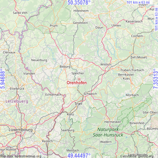
Orenhofen GPS coordinates[2]
49° 54' 0" North, 6° 39' 0" East
| Map corner | latitude | longitude |
|---|---|---|
| Upper-left | 50.35078°, | 5.94688° |
| Center: | 49.9°, | 6.65° |
| Lower-right: | 49.44497°, | 7.35313° |
| Map W x H: | 100.7×100.7 km | = 62.6×62.6mi |
| max Lat: | 55.01917° ⇑66.6% North |
| Orenhofen: | 49.9° |
| min Lat: | ⇓33.4% South 47.40724° |
| min Long | Orenhofen | max Long |
| 5.92978° | 6.65° | 14.98853° |
| W 3.3%⇐ | ⇒96.7% E |
Elevation
Elevation of Orenhofen is 341 m = 1119 ft, and this is 91.9 m = 302 ft above average elevation for this country.
| Max E: |
1256 m = 4121 ft | 32.3% |
| Orenhofen | 341 m 1119 ft | |
| Avg. | 249.1 m = 817 ft | |
Min E: |
-5 m = -16 ft | 67.7% |
See also: Germany elevation on elevation.city.
Geographical zone
Orenhofen is located in North temperate zone (between Tropic of Cancer and the Arctic Circle). Distance of this North polar circle is 1852.8 km =1151.3 mi to North.| Distance of | km | miles | from Orenhofen |
|---|---|---|---|
| North Pole | 4458.7 | 2770.5 | to North |
| Arctic Circle | 1852.8 | 1151.3 | to North |
| Tropic Cancer | 2942.4 | 1828.3 | to South |
| Equator | 5548.4 | 3447.6 | to South |


Nearby cities:
15 places around Orenhofen: (largest is in red/bold)
• Beilingen
5.7 km =3.5 mi,  12°
12°
• Dahlem
4 km =2.5 mi,  297°
297°
• Heidweiler
7.4 km =4.6 mi,  75°
75°
• Herforst
6.6 km =4.1 mi,  32°
32°
• Hosten
2.4 km =1.5 mi,  270°
270°
• Idenheim
6 km =3.7 mi, 270°
• Idesheim
6 km =3.7 mi,  243°
243°
• Kordel
7.5 km =4.7 mi,  189°
189°
• Philippsheim
5.7 km =3.5 mi,  347°
347°
• Preist
1.5 km =0.9 mi, 299°
• Röhl
6 km =3.7 mi,  307°
307°
• Speicher
3.9 km =2.4 mi,  342°
342°
• Sülm
6.2 km =3.9 mi,  287°
287°
• Trimport
5.1 km =3.2 mi, 291°
• Zemmer
3.6 km =2.2 mi,  90°
90°
Sources, notices
• [Note1] Compared only with cities in Germany existing in our database
• [Src1] Map data: © OpenStreetMap contributors (CC-BY-SA)
• [Src2] Other city data from geonames.org with taken over terms of usage.
• [Src3] Geographical zone / Annual Mean Temperature by Robert A. Rohde @ Wikipedia
