Röhl geodata
Röhl (Rheinland-Pfalz) is a seat of a fourth-order administrative division; located in Germany in Europe/Berlin (GMT+2) time zone. With population of 449 people, there are 9539 cities with bigger population in this country. Compared to other cities in Germany, 65.6% of cities are located further ↑North; 97.2% of cities are located further →East and 68.7% of cities have lower elevation than Röhl. Note1


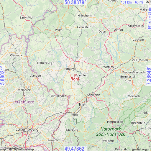
Röhl GPS coordinates[2]
49° 55' 59.988" North, 6° 34' 59.988" East
| Map corner | latitude | longitude |
|---|---|---|
| Upper-left | 50.38379°, | 5.88021° |
| Center: | 49.93333°, | 6.58333° |
| Lower-right: | 49.47862°, | 7.28646° |
| Map W x H: | 100.6×100.6 km | = 62.5×62.5mi |
| max Lat: | 55.01917° ⇑65.6% North |
| Röhl: | 49.93333° |
| min Lat: | ⇓34.4% South 47.40724° |
| min Long | Röhl | max Long |
| 5.92978° | 6.58333° | 14.98853° |
| W 2.8%⇐ | ⇒97.2% E |
Elevation
Elevation of Röhl is 348 m = 1142 ft, and this is 98.9 m = 324 ft above average elevation for this country.
| Max E: |
1256 m = 4121 ft | 31.3% |
| Röhl | 348 m 1142 ft | |
| Avg. | 249.1 m = 817 ft | |
Min E: |
-5 m = -16 ft | 68.7% |
See also: Germany elevation on elevation.city.
Geographical zone
Röhl is located in North temperate zone (between Tropic of Cancer and the Arctic Circle). Distance of this North polar circle is 1849.1 km =1149 mi to North.| Distance of | km | miles | from Röhl |
|---|---|---|---|
| North Pole | 4455 | 2768.2 | to North |
| Arctic Circle | 1849.1 | 1149 | to North |
| Tropic Cancer | 2946.1 | 1830.6 | to South |
| Equator | 5552.1 | 3449.9 | to South |


Nearby cities:
15 places around Röhl: (largest is in red/bold)
• Bitburg
5.6 km =3.5 mi,  313°
313°
• Dahlem
2.2 km =1.4 mi,  147°
147°
• Dudeldorf
6 km =3.7 mi,  39°
39°
• Gondorf
4.4 km =2.7 mi,  32°
32°
• Hosten
4.4 km =2.7 mi, 147°
• Idenheim
3.9 km =2.4 mi,  197°
197°
• Metterich
5.2 km =3.2 mi,  4°
4°
• Oberstedem
4.8 km =3 mi,  270°
270°
• Orenhofen
6 km =3.7 mi,  127°
127°
• Philippsheim
4 km =2.5 mi,  62°
62°
• Preist
4.6 km =2.9 mi, 130°
• Scharfbillig
2 km =1.2 mi, 266°
• Speicher
3.6 km =2.2 mi,  90°
90°
• Sülm
2.2 km =1.4 mi,  212°
212°
• Trimport
1.9 km =1.2 mi,  180°
180°
Sources, notices
• [Note1] Compared only with cities in Germany existing in our database
• [Src1] Map data: © OpenStreetMap contributors (CC-BY-SA)
• [Src2] Other city data from geonames.org with taken over terms of usage.
• [Src3] Geographical zone / Annual Mean Temperature by Robert A. Rohde @ Wikipedia
