Dahlem geodata
Dahlem (Rheinland-Pfalz) is a seat of a fourth-order administrative division; located in Germany in Europe/Berlin (GMT+2) time zone. With population of 235 people, there are 10333 cities with bigger population in this country. Compared to other cities in Germany, 66% of cities are located further ↑North; 97.1% of cities are located further →East and 64% of cities have lower elevation than Dahlem. Note1
Administrative division(s):
- Level 1: Rheinland-Pfalz
- Level 3: Eifelkreis Bitburg-Prüm
- Level 4: Dahlem


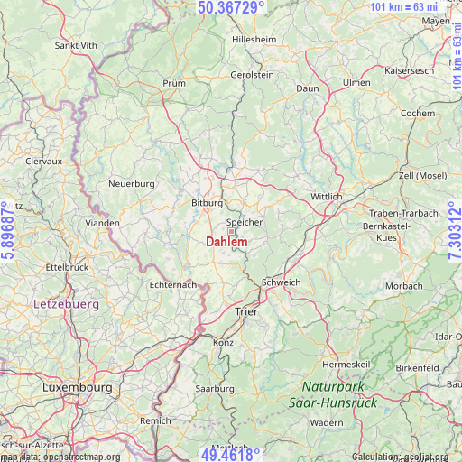
Dahlem GPS coordinates[2]
49° 55' 0.012" North, 6° 36' 0" East
| Map corner | latitude | longitude |
|---|---|---|
| Upper-left | 50.36729°, | 5.89687° |
| Center: | 49.91667°, | 6.6° |
| Lower-right: | 49.4618°, | 7.30312° |
| Map W x H: | 100.7×100.7 km | = 62.6×62.6mi |
| max Lat: | 55.01917° ⇑66% North |
| Dahlem: | 49.91667° |
| min Lat: | ⇓34% South 47.40724° |
| min Long | Dahlem | max Long |
| 5.92978° | 6.6° | 14.98853° |
| W 2.9%⇐ | ⇒97.1% E |
Elevation
Elevation of Dahlem is 315 m = 1033 ft, and this is 65.9 m = 216 ft above average elevation for this country.
| Max E: |
1256 m = 4121 ft | 36% |
| Dahlem | 315 m 1033 ft | |
| Avg. | 249.1 m = 817 ft | |
Min E: |
-5 m = -16 ft | 64% |
See also: Germany elevation on elevation.city.
Geographical zone
Dahlem is located in North temperate zone (between Tropic of Cancer and the Arctic Circle). Distance of this North polar circle is 1851 km =1150.2 mi to North.| Distance of | km | miles | from Dahlem |
|---|---|---|---|
| North Pole | 4456.8 | 2769.3 | to North |
| Arctic Circle | 1851 | 1150.2 | to North |
| Tropic Cancer | 2944.3 | 1829.5 | to South |
| Equator | 5550.2 | 3448.7 | to South |


Nearby cities:
15 places around Dahlem: (largest is in red/bold)
• Beilingen
6 km =3.7 mi,  52°
52°
• Gondorf
5.7 km =3.5 mi,  12°
12°
• Hosten
2.2 km =1.4 mi,  147°
147°
• Idenheim
3 km =1.9 mi,  232°
232°
• Idesheim
4.9 km =3 mi,  201°
201°
• Meckel
6.6 km =4.1 mi,  243°
243°
• Oberstedem
6.2 km =3.9 mi,  287°
287°
• Orenhofen
4 km =2.5 mi,  117°
117°
• Philippsheim
4.4 km =2.7 mi,  32°
32°
• Preist
2.5 km =1.6 mi, 116°
• Röhl
2.2 km =1.4 mi,  327°
327°
• Scharfbillig
3.6 km =2.2 mi,  298°
298°
• Speicher
3 km =1.9 mi, 52°
• Sülm
2.4 km =1.5 mi,  270°
270°
• Trimport
1.2 km =0.7 mi, 270°
Sources, notices
• [Note1] Compared only with cities in Germany existing in our database
• [Src1] Map data: © OpenStreetMap contributors (CC-BY-SA)
• [Src2] Other city data from geonames.org with taken over terms of usage.
• [Src3] Geographical zone / Annual Mean Temperature by Robert A. Rohde @ Wikipedia
