Oppurg geodata
Oppurg (Thuringia) is a seat of a fourth-order administrative division; located in Germany in Europe/Berlin (GMT+2) time zone. With population of 1,325 people, there are 6234 cities with bigger population in this country. Compared to other cities in Germany, 52.3% of cities are located further ↓South; 76.6% of cities are located further ←West and 51% of cities have higher elevation than Oppurg. Note1


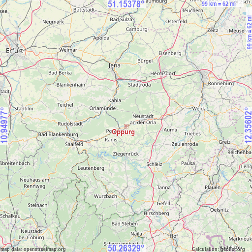
Oppurg GPS coordinates[2]
50° 42' 38.34" North, 11° 39' 10.404" East
| Map corner | latitude | longitude |
|---|---|---|
| Upper-left | 51.15378°, | 10.94977° |
| Center: | 50.71065°, | 11.65289° |
| Lower-right: | 50.26329°, | 12.35602° |
| Map W x H: | 99×99 km | = 61.5×61.5mi |
| max Lat: | 55.01917° ⇑47.7% North |
| Oppurg: | 50.71065° |
| min Lat: | ⇓52.3% South 47.40724° |
| min Long | Oppurg | max Long |
| 5.92978° | 11.65289° | 14.98853° |
| W 76.6%⇐ | ⇒23.4% E |
Elevation
Elevation of Oppurg is 218 m = 715 ft, and this is 31.1 m = 102 ft below average elevation for this country.
| Max E: |
1256 m = 4121 ft | 51% |
| Avg. | 249.1 m = 817 ft | |
| Oppurg | 218 m = 715 ft | |
Min E: |
-5 m = -16 ft | 49% |
See also: Germany elevation on elevation.city.
Geographical zone
Oppurg is located in North temperate zone (between Tropic of Cancer and the Arctic Circle). Distance of this North polar circle is 1762.7 km =1095.3 mi to North.| Distance of | km | miles | from Oppurg |
|---|---|---|---|
| North Pole | 4368.6 | 2714.5 | to North |
| Arctic Circle | 1762.7 | 1095.3 | to North |
| Tropic Cancer | 3032.6 | 1884.4 | to South |
| Equator | 5638.5 | 3503.6 | to South |


Nearby cities:
15 places around Oppurg: (largest is in red/bold)
• Bodelwitz
3.4 km =2.1 mi,  219°
219°
• Döbritz
1.2 km =0.7 mi,  189°
189°
• Gertewitz
3 km =1.9 mi,  183°
183°
• Grobengereuth
4.8 km =3 mi,  165°
165°
• Hummelshain
6.4 km =4 mi,  347°
347°
• Kospoda
6.9 km =4.3 mi,  84°
84°
• Langenorla
6.1 km =3.8 mi,  303°
303°
• Nimritz
1.2 km =0.7 mi, 189°
• Oberoppurg
2.4 km =1.5 mi,  118°
118°
• Peuschen
5.8 km =3.6 mi, 185°
• Pößneck
4.7 km =2.9 mi,  246°
246°
• Quaschwitz
4.5 km =2.8 mi,  132°
132°
• Solkwitz
1.5 km =0.9 mi,  140°
140°
• Weira
4.6 km =2.9 mi,  104°
104°
• Wernburg
5.1 km =3.2 mi, 224°
Sources, notices
• [Note1] Compared only with cities in Germany existing in our database
• [Src1] Map data: © OpenStreetMap contributors (CC-BY-SA)
• [Src2] Other city data from geonames.org with taken over terms of usage.
• [Src3] Geographical zone / Annual Mean Temperature by Robert A. Rohde @ Wikipedia
