Pößneck geodata
Pößneck (Thuringia) is a populated place; located in Germany in Europe/Berlin (GMT+2) time zone. With population of 13,624 people, there are 1175 cities with bigger population in this country. Compared to other cities in Germany, 51.8% of cities are located further ↓South; 75.6% of cities are located further ←West and 50.3% of cities have lower elevation than Pößneck. Note1


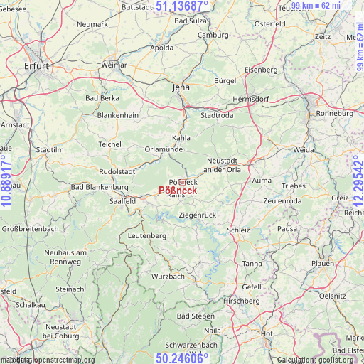
Pößneck GPS coordinates[2]
50° 41' 36.888" North, 11° 35' 32.244" East
| Map corner | latitude | longitude |
|---|---|---|
| Upper-left | 51.13687°, | 10.88917° |
| Center: | 50.69358°, | 11.59229° |
| Lower-right: | 50.24606°, | 12.29542° |
| Map W x H: | 99×99 km | = 61.5×61.5mi |
| max Lat: | 55.01917° ⇑48.2% North |
| Pößneck: | 50.69358° |
| min Lat: | ⇓51.8% South 47.40724° |
| min Long | Pößneck | max Long |
| 5.92978° | 11.59229° | 14.98853° |
| W 75.6%⇐ | ⇒24.4% E |
Elevation
Elevation of Pößneck is 228 m = 748 ft, and this is 21.1 m = 69 ft below average elevation for this country.
| Max E: |
1256 m = 4121 ft | 49.7% |
| Avg. | 249.1 m = 817 ft | |
| Pößneck | 228 m = 748 ft | |
Min E: |
-5 m = -16 ft | 50.3% |
See also: Germany elevation on elevation.city.
Geographical zone
Pößneck is located in North temperate zone (between Tropic of Cancer and the Arctic Circle). Distance of this North polar circle is 1764.6 km =1096.5 mi to North.| Distance of | km | miles | from Pößneck |
|---|---|---|---|
| North Pole | 4370.5 | 2715.7 | to North |
| Arctic Circle | 1764.6 | 1096.5 | to North |
| Tropic Cancer | 3030.7 | 1883.2 | to South |
| Equator | 5636.6 | 3502.4 | to South |


Nearby cities:
15 places around Pößneck: (largest is in red/bold)
• Bodelwitz
2.2 km =1.4 mi,  107°
107°
• Döbritz
4.1 km =2.5 mi,  80°
80°
• Gertewitz
4.2 km =2.6 mi, 105°
• Grobengereuth
6.1 km =3.8 mi,  116°
116°
• Herschdorf
4.4 km =2.7 mi,  297°
297°
• Krölpa
4.2 km =2.6 mi,  244°
244°
• Langenorla
5.3 km =3.3 mi,  350°
350°
• Moxa
5.6 km =3.5 mi,  149°
149°
• Nimritz
4.1 km =2.5 mi, 80°
• Oppurg
4.7 km =2.9 mi,  66°
66°
• Peuschen
5.3 km =3.3 mi,  136°
136°
• Ranis
3.9 km =2.4 mi,  204°
204°
• Schmorda
5.4 km =3.4 mi,  184°
184°
• Solkwitz
5.3 km =3.3 mi, 82°
• Wernburg
1.9 km =1.2 mi,  158°
158°
Sources, notices
• [Note1] Compared only with cities in Germany existing in our database
• [Src1] Map data: © OpenStreetMap contributors (CC-BY-SA)
• [Src2] Other city data from geonames.org with taken over terms of usage.
• [Src3] Geographical zone / Annual Mean Temperature by Robert A. Rohde @ Wikipedia
