Grobengereuth geodata
Grobengereuth (Thuringia) is a seat of a fourth-order administrative division; located in Germany in Europe/Berlin (GMT+2) time zone. With population of 248 people, there are 10266 cities with bigger population in this country. Compared to other cities in Germany, 51.3% of cities are located further ↓South; 76.8% of cities are located further ←West and 85.2% of cities have lower elevation than Grobengereuth. Note1


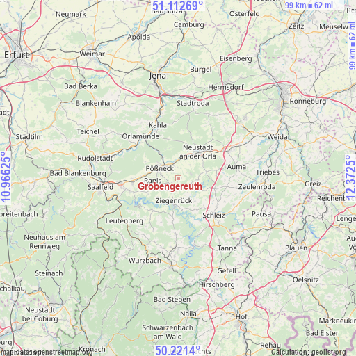
Grobengereuth GPS coordinates[2]
50° 40' 8.976" North, 11° 40' 9.732" East
| Map corner | latitude | longitude |
|---|---|---|
| Upper-left | 51.11269°, | 10.96625° |
| Center: | 50.66916°, | 11.66937° |
| Lower-right: | 50.2214°, | 12.3725° |
| Map W x H: | 99.1×99.1 km | = 61.6×61.6mi |
| max Lat: | 55.01917° ⇑48.7% North |
| Grobengereuth: | 50.66916° |
| min Lat: | ⇓51.3% South 47.40724° |
| min Long | Grobengereuth | max Long |
| 5.92978° | 11.66937° | 14.98853° |
| W 76.8%⇐ | ⇒23.2% E |
Elevation
Elevation of Grobengereuth is 471 m = 1545 ft, and this is 221.9 m = 728 ft above average elevation for this country.
| Max E: |
1256 m = 4121 ft | 14.8% |
| Grobengereuth | 471 m 1545 ft | |
| Avg. | 249.1 m = 817 ft | |
Min E: |
-5 m = -16 ft | 85.2% |
See also: Germany elevation on elevation.city.
Geographical zone
Grobengereuth is located in North temperate zone (between Tropic of Cancer and the Arctic Circle). Distance of this North polar circle is 1767.3 km =1098.1 mi to North.| Distance of | km | miles | from Grobengereuth |
|---|---|---|---|
| North Pole | 4373.2 | 2717.4 | to North |
| Arctic Circle | 1767.3 | 1098.1 | to North |
| Tropic Cancer | 3028 | 1881.5 | to South |
| Equator | 5633.9 | 3500.7 | to South |


Nearby cities:
15 places around Grobengereuth: (largest is in red/bold)
• Bodelwitz
3.9 km =2.4 mi,  301°
301°
• Bucha
4.5 km =2.8 mi,  151°
151°
• Döbritz
3.7 km =2.3 mi,  338°
338°
• Gertewitz
2.1 km =1.3 mi,  319°
319°
• Keila
3.6 km =2.2 mi,  188°
188°
• Knau
4.1 km =2.5 mi,  120°
120°
• Moxa
3.3 km =2.1 mi,  230°
230°
• Nimritz
3.7 km =2.3 mi, 338°
• Oberoppurg
3.6 km =2.2 mi,  16°
16°
• Oppurg
4.8 km =3 mi,  345°
345°
• Peuschen
2.1 km =1.3 mi,  236°
236°
• Quaschwitz
2.7 km =1.7 mi,  53°
53°
• Solkwitz
3.4 km =2.1 mi,  356°
356°
• Weira
4.8 km =3 mi,  44°
44°
• Wernburg
4.8 km =3 mi,  281°
281°
Sources, notices
• [Note1] Compared only with cities in Germany existing in our database
• [Src1] Map data: © OpenStreetMap contributors (CC-BY-SA)
• [Src2] Other city data from geonames.org with taken over terms of usage.
• [Src3] Geographical zone / Annual Mean Temperature by Robert A. Rohde @ Wikipedia
