Oberscheinfeld geodata
Oberscheinfeld (Bavaria) is a populated place; located in Germany in Europe/Berlin (GMT+2) time zone. With population of 1,315 people, there are 6264 cities with bigger population in this country. Compared to other cities in Germany, 71.2% of cities are located further ↑North; 57.8% of cities are located further ←West and 65.2% of cities have lower elevation than Oberscheinfeld. Note1
Administrative division(s):
- Level 1: Bavaria
- Level 2: Regierungsbezirk Mittelfranken
- Level 3: Landkreis Neustadt an der Aisch-Bad Windsheim
- Level 4: Oberscheinfeld, Markt


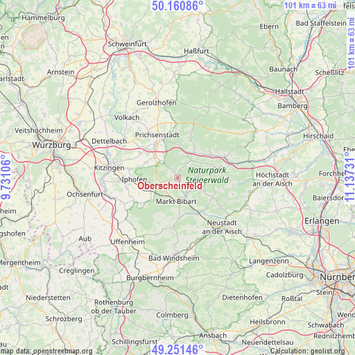
Oberscheinfeld GPS coordinates[2]
49° 42' 29.844" North, 10° 26' 3.048" East
| Map corner | latitude | longitude |
|---|---|---|
| Upper-left | 50.16086°, | 9.73106° |
| Center: | 49.70829°, | 10.43418° |
| Lower-right: | 49.25146°, | 11.13731° |
| Map W x H: | 101.1×101.1 km | = 62.8×62.8mi |
| max Lat: | 55.01917° ⇑71.2% North |
| Oberscheinfeld: | 49.70829° |
| min Lat: | ⇓28.8% South 47.40724° |
| min Long | Oberscheinfeld | max Long |
| 5.92978° | 10.43418° | 14.98853° |
| W 57.8%⇐ | ⇒42.2% E |
Elevation
Elevation of Oberscheinfeld is 323 m = 1060 ft, and this is 73.9 m = 242 ft above average elevation for this country.
| Max E: |
1256 m = 4121 ft | 34.8% |
| Oberscheinfeld | 323 m 1060 ft | |
| Avg. | 249.1 m = 817 ft | |
Min E: |
-5 m = -16 ft | 65.2% |
See also: Germany elevation on elevation.city.
Geographical zone
Oberscheinfeld is located in North temperate zone (between Tropic of Cancer and the Arctic Circle). Distance of this North polar circle is 1874.1 km =1164.5 mi to North.| Distance of | km | miles | from Oberscheinfeld |
|---|---|---|---|
| North Pole | 4480 | 2783.7 | to North |
| Arctic Circle | 1874.1 | 1164.5 | to North |
| Tropic Cancer | 2921.1 | 1815.1 | to South |
| Equator | 5527 | 3434.3 | to South |


Nearby cities:
15 places around Oberscheinfeld: (largest is in red/bold)
• Abtswind
8.2 km =5.1 mi,  327°
327°
• Baudenbach
11.8 km =7.3 mi,  141°
141°
• Burghaslach
12.3 km =7.6 mi,  77°
77°
• Castell
7.1 km =4.4 mi,  301°
301°
• Geiselwind
7.7 km =4.8 mi,  19°
19°
• Iphofen
12.5 km =7.8 mi,  266°
266°
• Langenfeld
11.8 km =7.3 mi,  149°
149°
• Markt Bibart
6.8 km =4.2 mi,  185°
185°
• Markt Einersheim
10.5 km =6.5 mi,  256°
256°
• Markt Taschendorf
8.8 km =5.5 mi,  95°
95°
• Rüdenhausen
9.2 km =5.7 mi,  313°
313°
• Scheinfeld
4.9 km =3 mi, 152°
• Sugenheim
11.7 km =7.3 mi,  179°
179°
• Wiesenbronn
10.7 km =6.6 mi, 295°
• Wiesentheid
11.5 km =7.1 mi, 326°
Sources, notices
• [Note1] Compared only with cities in Germany existing in our database
• [Src1] Map data: © OpenStreetMap contributors (CC-BY-SA)
• [Src2] Other city data from geonames.org with taken over terms of usage.
• [Src3] Geographical zone / Annual Mean Temperature by Robert A. Rohde @ Wikipedia
