Langenfeld geodata
Langenfeld (Bavaria) is a seat of a fourth-order administrative division; located in Germany in Europe/Berlin (GMT+2) time zone. With population of 1,022 people, there are 7103 cities with bigger population in this country. Compared to other cities in Germany, 73.5% of cities are located further ↑North; 59.1% of cities are located further ←West and 60.9% of cities have lower elevation than Langenfeld. Note1
Administrative division(s):
- Level 1: Bavaria
- Level 2: Regierungsbezirk Mittelfranken
- Level 3: Landkreis Neustadt an der Aisch-Bad Windsheim
- Level 4: Langenfeld


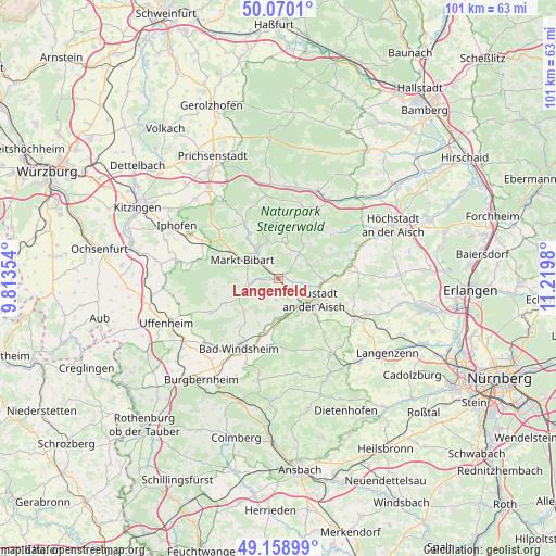
Langenfeld GPS coordinates[2]
49° 37' 0.012" North, 10° 31' 0.012" East
| Map corner | latitude | longitude |
|---|---|---|
| Upper-left | 50.0701°, | 9.81354° |
| Center: | 49.61667°, | 10.51667° |
| Lower-right: | 49.15899°, | 11.2198° |
| Map W x H: | 101.3×101.3 km | = 62.9×62.9mi |
| max Lat: | 55.01917° ⇑73.5% North |
| Langenfeld: | 49.61667° |
| min Lat: | ⇓26.5% South 47.40724° |
| min Long | Langenfeld | max Long |
| 5.92978° | 10.51667° | 14.98853° |
| W 59.1%⇐ | ⇒40.9% E |
Elevation
Elevation of Langenfeld is 295 m = 968 ft, and this is 45.9 m = 151 ft above average elevation for this country.
| Max E: |
1256 m = 4121 ft | 39.1% |
| Langenfeld | 295 m 968 ft | |
| Avg. | 249.1 m = 817 ft | |
Min E: |
-5 m = -16 ft | 60.9% |
See also: Germany elevation on elevation.city.
Geographical zone
Langenfeld is located in North temperate zone (between Tropic of Cancer and the Arctic Circle). Distance of this North polar circle is 1884.3 km =1170.8 mi to North.| Distance of | km | miles | from Langenfeld |
|---|---|---|---|
| North Pole | 4490.2 | 2790.1 | to North |
| Arctic Circle | 1884.3 | 1170.8 | to North |
| Tropic Cancer | 2910.9 | 1808.7 | to South |
| Equator | 5516.9 | 3428 | to South |


Nearby cities:
15 places around Langenfeld: (largest is in red/bold)
• Baudenbach
1.7 km =1.1 mi,  55°
55°
• Diespeck
8.6 km =5.3 mi,  102°
102°
• Dietersheim
6.9 km =4.3 mi,  165°
165°
• Gerhardshofen
12.7 km =7.9 mi,  82°
82°
• Gutenstetten
8.4 km =5.2 mi,  90°
90°
• Ipsheim
10.2 km =6.3 mi,  194°
194°
• Markt Bibart
7.5 km =4.7 mi,  297°
297°
• Markt Nordheim
12 km =7.5 mi,  256°
256°
• Markt Taschendorf
9.8 km =6.1 mi,  16°
16°
• Münchsteinach
6.2 km =3.9 mi,  65°
65°
• Neustadt an der Aisch
8 km =5 mi,  121°
121°
• Oberscheinfeld
11.8 km =7.3 mi,  329°
329°
• Scheinfeld
6.9 km =4.3 mi, 327°
• Sugenheim
6 km =3.7 mi, 255°
• Vestenbergsgreuth
12.5 km =7.8 mi,  50°
50°
Sources, notices
• [Note1] Compared only with cities in Germany existing in our database
• [Src1] Map data: © OpenStreetMap contributors (CC-BY-SA)
• [Src2] Other city data from geonames.org with taken over terms of usage.
• [Src3] Geographical zone / Annual Mean Temperature by Robert A. Rohde @ Wikipedia
