Castell geodata
Castell (Bavaria) is a seat of a fourth-order administrative division; located in Germany in Europe/Berlin (GMT+2) time zone. With population of 820 people, there are 7825 cities with bigger population in this country. Compared to other cities in Germany, 70.3% of cities are located further ↑North; 56.3% of cities are located further ←West and 61.1% of cities have lower elevation than Castell. Note1
Administrative division(s):
- Level 1: Bavaria
- Level 2: Regierungsbezirk Unterfranken
- Level 3: Landkreis Kitzingen
- Level 4: Castell


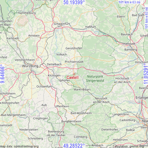
Castell GPS coordinates[2]
49° 44' 30.228" North, 10° 20' 59.208" East
| Map corner | latitude | longitude |
|---|---|---|
| Upper-left | 50.19399°, | 9.64666° |
| Center: | 49.74173°, | 10.34978° |
| Lower-right: | 49.28522°, | 11.05291° |
| Map W x H: | 101×101 km | = 62.8×62.8mi |
| max Lat: | 55.01917° ⇑70.3% North |
| Castell: | 49.74173° |
| min Lat: | ⇓29.7% South 47.40724° |
| min Long | Castell | max Long |
| 5.92978° | 10.34978° | 14.98853° |
| W 56.3%⇐ | ⇒43.7% E |
Elevation
Elevation of Castell is 296 m = 971 ft, and this is 46.9 m = 154 ft above average elevation for this country.
| Max E: |
1256 m = 4121 ft | 38.9% |
| Castell | 296 m 971 ft | |
| Avg. | 249.1 m = 817 ft | |
Min E: |
-5 m = -16 ft | 61.1% |
See also: Germany elevation on elevation.city.
Geographical zone
Castell is located in North temperate zone (between Tropic of Cancer and the Arctic Circle). Distance of this North polar circle is 1870.4 km =1162.2 mi to North.| Distance of | km | miles | from Castell |
|---|---|---|---|
| North Pole | 4476.3 | 2781.4 | to North |
| Arctic Circle | 1870.4 | 1162.2 | to North |
| Tropic Cancer | 2924.8 | 1817.4 | to South |
| Equator | 5530.8 | 3436.7 | to South |


Nearby cities:
15 places around Castell: (largest is in red/bold)
• Abtswind
3.6 km =2.2 mi,  28°
28°
• Geiselwind
9.4 km =5.8 mi,  67°
67°
• Großlangheim
8 km =5 mi,  281°
281°
• Iphofen
7.8 km =4.8 mi,  235°
235°
• Kleinlangheim
5.7 km =3.5 mi,  304°
304°
• Mainbernheim
10.1 km =6.3 mi,  248°
248°
• Markt Einersheim
7.4 km =4.6 mi,  214°
214°
• Oberscheinfeld
7.1 km =4.4 mi,  121°
121°
• Prichsenstadt
8.6 km =5.3 mi,  359°
359°
• Rödelsee
7.8 km =4.8 mi,  259°
259°
• Rüdenhausen
2.7 km =1.7 mi,  344°
344°
• Scheinfeld
11.6 km =7.2 mi,  134°
134°
• Wiesenbronn
3.7 km =2.3 mi, 284°
• Wiesentheid
5.9 km =3.7 mi, 356°
• Willanzheim
10.9 km =6.8 mi,  230°
230°
Sources, notices
• [Note1] Compared only with cities in Germany existing in our database
• [Src1] Map data: © OpenStreetMap contributors (CC-BY-SA)
• [Src2] Other city data from geonames.org with taken over terms of usage.
• [Src3] Geographical zone / Annual Mean Temperature by Robert A. Rohde @ Wikipedia
