Oberotterbach geodata
Oberotterbach (Rheinland-Pfalz) is a seat of a fourth-order administrative division; located in Germany in Europe/Berlin (GMT+2) time zone. With population of 1,275 people, there are 6379 cities with bigger population in this country. Compared to other cities in Germany, 82.1% of cities are located further ↑North; 77.6% of cities are located further →East and 53.7% of cities have higher elevation than Oberotterbach. Note1
Administrative division(s):
- Level 1: Rheinland-Pfalz
- Level 3: Landkreis Südliche Weinstraße
- Level 4: Oberotterbach


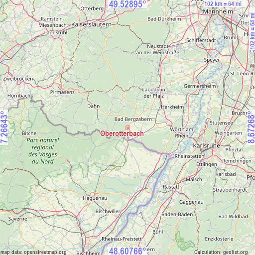
Oberotterbach GPS coordinates[2]
49° 4' 13.584" North, 7° 58' 10.38" East
| Map corner | latitude | longitude |
|---|---|---|
| Upper-left | 49.52895°, | 7.26643° |
| Center: | 49.07044°, | 7.96955° |
| Lower-right: | 48.60766°, | 8.67268° |
| Map W x H: | 102.4×102.4 km | = 63.6×63.6mi |
| max Lat: | 55.01917° ⇑82.1% North |
| Oberotterbach: | 49.07044° |
| min Lat: | ⇓17.9% South 47.40724° |
| min Long | Oberotterbach | max Long |
| 5.92978° | 7.96955° | 14.98853° |
| W 22.4%⇐ | ⇒77.6% E |
Elevation
Elevation of Oberotterbach is 199 m = 653 ft, and this is 50.1 m = 164 ft below average elevation for this country.
| Max E: |
1256 m = 4121 ft | 53.7% |
| Avg. | 249.1 m = 817 ft | |
| Oberotterbach | 199 m = 653 ft | |
Min E: |
-5 m = -16 ft | 46.3% |
See also: Germany elevation on elevation.city.
Geographical zone
Oberotterbach is located in North temperate zone (between Tropic of Cancer and the Arctic Circle). Distance of this North polar circle is 1945.1 km =1208.6 mi to North.| Distance of | km | miles | from Oberotterbach |
|---|---|---|---|
| North Pole | 4550.9 | 2827.8 | to North |
| Arctic Circle | 1945.1 | 1208.6 | to North |
| Tropic Cancer | 2850.2 | 1771 | to South |
| Equator | 5456.1 | 3390.3 | to South |


Nearby cities:
15 places around Oberotterbach: (largest is in red/bold)
• Bad Bergzabern
4.2 km =2.6 mi,  32°
32°
• Birkenhördt
5.8 km =3.6 mi,  332°
332°
• Böllenborn
4.2 km =2.6 mi,  321°
321°
• Dierbach
7.2 km =4.5 mi,  80°
80°
• Dörrenbach
2.2 km =1.4 mi,  344°
344°
• Gleiszellen-Gleishorbach
6.7 km =4.2 mi,  23°
23°
• Kapellen-Drusweiler
5.7 km =3.5 mi,  52°
52°
• Kapsweyer
4.8 km =3 mi,  127°
127°
• Niederhorbach
6.9 km =4.3 mi,  43°
43°
• Niederotterbach
5.7 km =3.5 mi,  101°
101°
• Oberhausen
7.1 km =4.4 mi,  65°
65°
• Pleisweiler-Oberhofen
6 km =3.7 mi, 27°
• Schweigen-Rechtenbach
2.1 km =1.3 mi,  206°
206°
• Schweighofen
3.8 km =2.4 mi,  152°
152°
• Steinfeld
5.5 km =3.4 mi,  116°
116°
Sources, notices
• [Note1] Compared only with cities in Germany existing in our database
• [Src1] Map data: © OpenStreetMap contributors (CC-BY-SA)
• [Src2] Other city data from geonames.org with taken over terms of usage.
• [Src3] Geographical zone / Annual Mean Temperature by Robert A. Rohde @ Wikipedia
