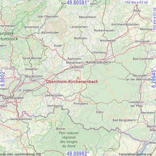
Obernheim-Kirchenarnbach geodata
Obernheim-Kirchenarnbach (Rheinland-Pfalz) is a seat of a fourth-order administrative division; located in Germany in Europe/Berlin (GMT+2) time zone. With population of 1,831 people, there are 5298 cities with bigger population in this country. Compared to other cities in Germany, 78% of cities are located further ↑North; 85.4% of cities are located further →East and 78.3% of cities have lower elevation than Obernheim-Kirchenarnbach. Note1
Administrative division(s):
- Level 1: Rheinland-Pfalz
- Level 3: Südwestpfalz
- Level 4: Obernheim-Kirchenarnbach
Current local time in Obernheim-Kirchenarnbach:
05:11 PM, TuesdayDifference from your time zone: hours


Obernheim-Kirchenarnbach GPS coordinates[2]
49° 21' 0" North, 7° 34' 59.988" East
| Map corner | latitude | longitude |
|---|---|---|
| Upper-left | 49.80591°, | 6.8802° |
| Center: | 49.35°, | 7.58333° |
| Lower-right: | 48.88982°, | 8.28645° |
| Map W x H: | 101.9×101.9 km | = 63.3×63.3mi |
| max Lat: | 55.01917° ⇑78% North |
| Obernheim-Kirchenarnbach: | 49.35° |
| min Lat: | ⇓22% South 47.40724° |
| min Long | Obernheim-Kirch | max Long |
| 5.92978° | 7.58333° | 14.98853° |
| W 14.6%⇐ | ⇒85.4% E |
Elevation
Elevation of Obernheim-Kirchenarnbach is 422 m = 1385 ft, and this is 172.9 m = 567 ft above average elevation for this country.
| Max E: |
1256 m = 4121 ft | 21.7% |
| Obernheim-Kirchenarnbach | 422 m 1385 ft | |
| Avg. | 249.1 m = 817 ft | |
Min E: |
-5 m = -16 ft | 78.3% |
See also: Germany elevation on elevation.city.
Geographical zone
Obernheim-Kirchenarnbach is located in North temperate zone (between Tropic of Cancer and the Arctic Circle). Distance of this North polar circle is 1914 km =1189.3 mi to North.| Distance of | km | miles | from Obernheim-Kirchenarnbach |
|---|---|---|---|
| North Pole | 4519.9 | 2808.5 | to North |
| Arctic Circle | 1914 | 1189.3 | to North |
| Tropic Cancer | 2881.3 | 1790.4 | to South |
| Equator | 5487.2 | 3409.6 | to South |


Nearby cities:
15 places around Obernheim-Kirchenarnbach: (largest is in red/bold)
• Bann
4.4 km =2.7 mi,  33°
33°
• Gerhardsbrunn
4.8 km =3 mi,  270°
270°
• Hermersberg
5.2 km =3.2 mi,  135°
135°
• Herschberg
5.6 km =3.5 mi,  206°
206°
• Hettenhausen
3 km =1.9 mi,  232°
232°
• Horbach
5.2 km =3.2 mi,  110°
110°
• Linden
4.8 km =3 mi,  90°
90°
• Mittelbrunn
3 km =1.9 mi,  307°
307°
• Oberarnbach
3.7 km =2.3 mi,  0°
0°
• Queidersbach
4.1 km =2.5 mi,  62°
62°
• Saalstadt
4.4 km =2.7 mi, 213°
• Schauerberg
3.7 km =2.3 mi,  180°
180°
• Steinalben
6.1 km =3.8 mi,  127°
127°
• Wallhalben
5.8 km =3.6 mi, 230°
• Weselberg
2.3 km =1.4 mi, 130°
Sources, notices
• [Note1] Compared only with cities in Germany existing in our database
• [Src1] Map data: © OpenStreetMap contributors (CC-BY-SA)
• [Src2] Other city data from geonames.org with taken over terms of usage.
• [Src3] Geographical zone / Annual Mean Temperature by Robert A. Rohde @ Wikipedia
