Oberarnbach geodata
Oberarnbach (Rheinland-Pfalz) is a seat of a fourth-order administrative division; located in Germany in Europe/Berlin (GMT+2) time zone. With population of 440 people, there are 9572 cities with bigger population in this country. Compared to other cities in Germany, 77.4% of cities are located further ↑North; 85.4% of cities are located further →East and 68.9% of cities have lower elevation than Oberarnbach. Note1
Administrative division(s):
- Level 1: Rheinland-Pfalz
- Level 3: Landkreis Kaiserslautern
- Level 4: Oberarnbach


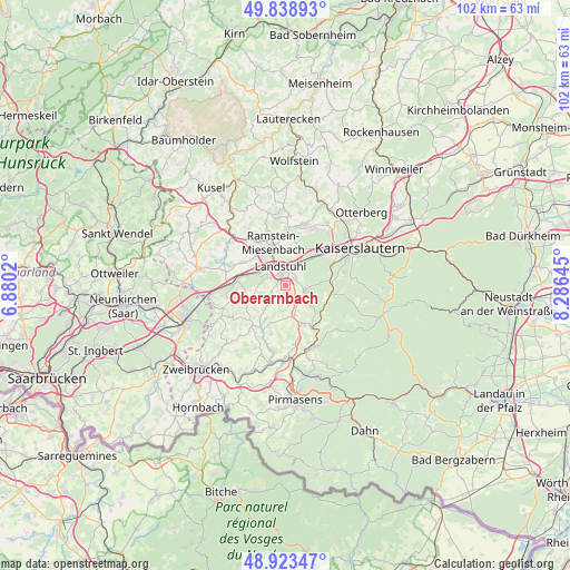
Oberarnbach GPS coordinates[2]
49° 22' 59.988" North, 7° 34' 59.988" East
| Map corner | latitude | longitude |
|---|---|---|
| Upper-left | 49.83893°, | 6.8802° |
| Center: | 49.38333°, | 7.58333° |
| Lower-right: | 48.92347°, | 8.28645° |
| Map W x H: | 101.8×101.8 km | = 63.3×63.3mi |
| max Lat: | 55.01917° ⇑77.4% North |
| Oberarnbach: | 49.38333° |
| min Lat: | ⇓22.6% South 47.40724° |
| min Long | Oberarnbach | max Long |
| 5.92978° | 7.58333° | 14.98853° |
| W 14.6%⇐ | ⇒85.4% E |
Elevation
Elevation of Oberarnbach is 350 m = 1148 ft, and this is 100.9 m = 331 ft above average elevation for this country.
| Max E: |
1256 m = 4121 ft | 31.1% |
| Oberarnbach | 350 m 1148 ft | |
| Avg. | 249.1 m = 817 ft | |
Min E: |
-5 m = -16 ft | 68.9% |
See also: Germany elevation on elevation.city.
Geographical zone
Oberarnbach is located in North temperate zone (between Tropic of Cancer and the Arctic Circle). Distance of this North polar circle is 1910.3 km =1187 mi to North.| Distance of | km | miles | from Oberarnbach |
|---|---|---|---|
| North Pole | 4516.2 | 2806.2 | to North |
| Arctic Circle | 1910.3 | 1187 | to North |
| Tropic Cancer | 2885 | 1792.7 | to South |
| Equator | 5490.9 | 3411.9 | to South |


Nearby cities:
15 places around Oberarnbach: (largest is in red/bold)
• Bann
2.4 km =1.5 mi,  90°
90°
• Gerhardsbrunn
6.1 km =3.8 mi,  232°
232°
• Hettenhausen
6.1 km =3.8 mi,  203°
203°
• Horbach
7.4 km =4.6 mi,  139°
139°
• Kindsbach
4.4 km =2.7 mi,  33°
33°
• Krickenbach
6.3 km =3.9 mi,  107°
107°
• Landstuhl
3.4 km =2.1 mi,  343°
343°
• Langwieden
6 km =3.7 mi,  270°
270°
• Linden
6.1 km =3.8 mi,  127°
127°
• Mittelbrunn
3 km =1.9 mi, 232°
• Obernheim-Kirchenarnbach
3.7 km =2.3 mi,  180°
180°
• Queidersbach
4.1 km =2.5 mi,  117°
117°
• Ramstein-Miesenbach
7.1 km =4.4 mi, 343°
• Schauerberg
7.4 km =4.6 mi, 180°
• Weselberg
5.5 km =3.4 mi,  161°
161°
Sources, notices
• [Note1] Compared only with cities in Germany existing in our database
• [Src1] Map data: © OpenStreetMap contributors (CC-BY-SA)
• [Src2] Other city data from geonames.org with taken over terms of usage.
• [Src3] Geographical zone / Annual Mean Temperature by Robert A. Rohde @ Wikipedia
