Herschberg geodata
Herschberg (Rheinland-Pfalz) is a seat of a fourth-order administrative division; located in Germany in Europe/Berlin (GMT+2) time zone. With population of 936 people, there are 7401 cities with bigger population in this country. Compared to other cities in Germany, 78.6% of cities are located further ↑North; 86.1% of cities are located further →East and 73.7% of cities have lower elevation than Herschberg. Note1


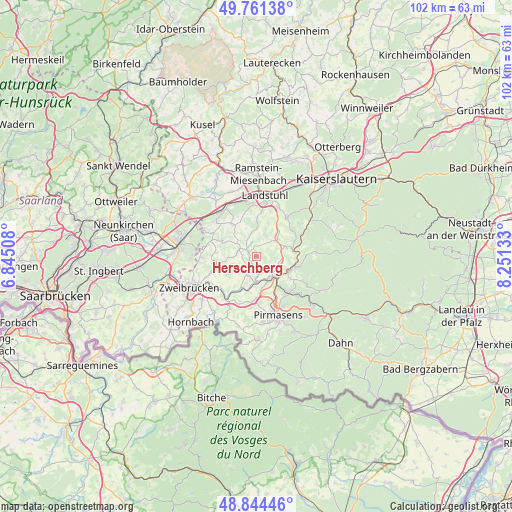
Herschberg GPS coordinates[2]
49° 18' 18.18" North, 7° 32' 53.52" East
| Map corner | latitude | longitude |
|---|---|---|
| Upper-left | 49.76138°, | 6.84508° |
| Center: | 49.30505°, | 7.5482° |
| Lower-right: | 48.84446°, | 8.25133° |
| Map W x H: | 102×102 km | = 63.4×63.4mi |
| max Lat: | 55.01917° ⇑78.6% North |
| Herschberg: | 49.30505° |
| min Lat: | ⇓21.4% South 47.40724° |
| min Long | Herschberg | max Long |
| 5.92978° | 7.5482° | 14.98853° |
| W 13.9%⇐ | ⇒86.1% E |
Elevation
Elevation of Herschberg is 388 m = 1273 ft, and this is 138.9 m = 456 ft above average elevation for this country.
| Max E: |
1256 m = 4121 ft | 26.3% |
| Herschberg | 388 m 1273 ft | |
| Avg. | 249.1 m = 817 ft | |
Min E: |
-5 m = -16 ft | 73.7% |
See also: Germany elevation on elevation.city.
Geographical zone
Herschberg is located in North temperate zone (between Tropic of Cancer and the Arctic Circle). Distance of this North polar circle is 1919 km =1192.4 mi to North.| Distance of | km | miles | from Herschberg |
|---|---|---|---|
| North Pole | 4524.9 | 2811.6 | to North |
| Arctic Circle | 1919 | 1192.4 | to North |
| Tropic Cancer | 2876.3 | 1787.2 | to South |
| Equator | 5482.2 | 3406.5 | to South |


Nearby cities:
15 places around Herschberg: (largest is in red/bold)
• Biedershausen
4.9 km =3 mi,  285°
285°
• Gerhardsbrunn
5.5 km =3.4 mi,  335°
335°
• Hettenhausen
3.1 km =1.9 mi,  2°
2°
• Höheinöd
4.6 km =2.9 mi,  111°
111°
• Knopp-Labach
4.7 km =2.9 mi,  311°
311°
• Maßweiler
4.4 km =2.7 mi,  194°
194°
• Obernheim-Kirchenarnbach
5.6 km =3.5 mi,  26°
26°
• Reifenberg
3.7 km =2.3 mi,  228°
228°
• Saalstadt
1.3 km =0.8 mi,  5°
5°
• Schauerberg
2.9 km =1.8 mi,  63°
63°
• Schmitshausen
2.4 km =1.5 mi,  256°
256°
• Thaleischweiler-Fröschen
5 km =3.1 mi,  149°
149°
• Wallhalben
2.4 km =1.5 mi,  304°
304°
• Weselberg
5.6 km =3.5 mi,  50°
50°
• Winterbach
5.4 km =3.4 mi,  267°
267°
Sources, notices
• [Note1] Compared only with cities in Germany existing in our database
• [Src1] Map data: © OpenStreetMap contributors (CC-BY-SA)
• [Src2] Other city data from geonames.org with taken over terms of usage.
• [Src3] Geographical zone / Annual Mean Temperature by Robert A. Rohde @ Wikipedia
