Oberalben geodata
Oberalben (Rheinland-Pfalz) is a seat of a fourth-order administrative division; located in Germany in Europe/Berlin (GMT+2) time zone. With population of 270 people, there are 10165 cities with bigger population in this country. Compared to other cities in Germany, 74.2% of cities are located further ↑North; 88.7% of cities are located further →East and 62.7% of cities have lower elevation than Oberalben. Note1


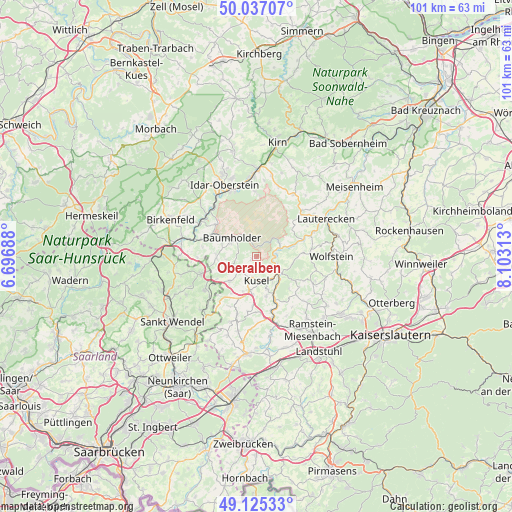
Oberalben GPS coordinates[2]
49° 34' 59.988" North, 7° 24' 0" East
| Map corner | latitude | longitude |
|---|---|---|
| Upper-left | 50.03707°, | 6.69688° |
| Center: | 49.58333°, | 7.4° |
| Lower-right: | 49.12533°, | 8.10313° |
| Map W x H: | 101.4×101.4 km | = 63×63mi |
| max Lat: | 55.01917° ⇑74.2% North |
| Oberalben: | 49.58333° |
| min Lat: | ⇓25.8% South 47.40724° |
| min Long | Oberalben | max Long |
| 5.92978° | 7.4° | 14.98853° |
| W 11.3%⇐ | ⇒88.7% E |
Elevation
Elevation of Oberalben is 306 m = 1004 ft, and this is 56.9 m = 187 ft above average elevation for this country.
| Max E: |
1256 m = 4121 ft | 37.3% |
| Oberalben | 306 m 1004 ft | |
| Avg. | 249.1 m = 817 ft | |
Min E: |
-5 m = -16 ft | 62.7% |
See also: Germany elevation on elevation.city.
Geographical zone
Oberalben is located in North temperate zone (between Tropic of Cancer and the Arctic Circle). Distance of this North polar circle is 1888 km =1173.1 mi to North.| Distance of | km | miles | from Oberalben |
|---|---|---|---|
| North Pole | 4493.9 | 2792.4 | to North |
| Arctic Circle | 1888 | 1173.1 | to North |
| Tropic Cancer | 2907.2 | 1806.4 | to South |
| Equator | 5513.1 | 3425.7 | to South |


Nearby cities:
15 places around Oberalben: (largest is in red/bold)
• Altenglan
6.1 km =3.8 mi,  127°
127°
• Bedesbach
4.5 km =2.8 mi,  111°
111°
• Blaubach
1.9 km =1.2 mi,  180°
180°
• Dennweiler-Frohnbach
1.2 km =0.7 mi,  270°
270°
• Erdesbach
3.2 km =2 mi, 108°
• Haschbach am Remigiusberg
6.1 km =3.8 mi,  156°
156°
• Kusel
5.1 km =3.2 mi, 176°
• Körborn
3 km =1.9 mi,  232°
232°
• Mettweiler
6 km =3.7 mi, 270°
• Niederalben
5.2 km =3.2 mi,  68°
68°
• Rammelsbach
5.6 km =3.5 mi,  145°
145°
• Rathsweiler
5.2 km =3.2 mi, 68°
• Ruthweiler
4.4 km =2.7 mi,  212°
212°
• Thallichtenberg
4.5 km =2.8 mi, 231°
• Ulmet
3.6 km =2.2 mi,  90°
90°
Sources, notices
• [Note1] Compared only with cities in Germany existing in our database
• [Src1] Map data: © OpenStreetMap contributors (CC-BY-SA)
• [Src2] Other city data from geonames.org with taken over terms of usage.
• [Src3] Geographical zone / Annual Mean Temperature by Robert A. Rohde @ Wikipedia
