Nusplingen geodata
Nusplingen (Baden-Württemberg) is a seat of a fourth-order administrative division; located in Germany in Europe/Berlin (GMT+2) time zone. In our database, there are 11009 cities with bigger population. Compared to other cities in Germany, 93.6% of cities are located further ↑North; 66.7% of cities are located further →East and 98.3% of cities have lower elevation than Nusplingen. Note1
Administrative division(s):
- Level 1: Baden-Württemberg
- Level 2: Tübingen Region
- Level 3: Zollernalbkreis
- Level 4: Nusplingen


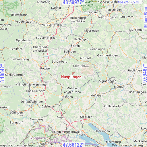
Nusplingen GPS coordinates[2]
48° 7' 57.504" North, 8° 53' 29.544" East
| Map corner | latitude | longitude |
|---|---|---|
| Upper-left | 48.59977°, | 8.18842° |
| Center: | 48.13264°, | 8.89154° |
| Lower-right: | 47.66122°, | 9.59467° |
| Map W x H: | 104.4×104.4 km | = 64.9×64.9mi |
| max Lat: | 55.01917° ⇑93.6% North |
| Nusplingen: | 48.13264° |
| min Lat: | ⇓6.4% South 47.40724° |
| min Long | Nusplingen | max Long |
| 5.92978° | 8.89154° | 14.98853° |
| W 33.3%⇐ | ⇒66.7% E |
Elevation
Elevation of Nusplingen is 721 m = 2365 ft, and this is 471.9 m = 1548 ft above average elevation for this country.
| Max E: |
1256 m = 4121 ft | 1.7% |
| Nusplingen | 721 m 2365 ft | |
| Avg. | 249.1 m = 817 ft | |
Min E: |
-5 m = -16 ft | 98.3% |
See also: Germany elevation on elevation.city.
Geographical zone
Nusplingen is located in North temperate zone (between Tropic of Cancer and the Arctic Circle). Distance of this North polar circle is 2049.3 km =1273.4 mi to North.| Distance of | km | miles | from Nusplingen |
|---|---|---|---|
| North Pole | 4655.2 | 2892.6 | to North |
| Arctic Circle | 2049.3 | 1273.4 | to North |
| Tropic Cancer | 2745.9 | 1706.2 | to South |
| Equator | 5351.8 | 3325.5 | to South |


Nearby cities:
15 places around Nusplingen: (largest is in red/bold)
• Bubsheim
4.7 km =2.9 mi,  247°
247°
• Bärenthal
8 km =5 mi,  157°
157°
• Böttingen
7.7 km =4.8 mi,  241°
241°
• Deilingen
9.1 km =5.7 mi,  300°
300°
• Egesheim
3.1 km =1.9 mi, 236°
• Hausen am Tann
8.4 km =5.2 mi,  330°
330°
• Irndorf
9.2 km =5.7 mi,  142°
142°
• Kolbingen
8.9 km =5.5 mi,  180°
180°
• Königsheim
4.1 km =2.5 mi,  206°
206°
• Meßstetten
7.9 km =4.9 mi,  44°
44°
• Obernheim
4.1 km =2.5 mi, 326°
• Reichenbach am Heuberg
3.1 km =1.9 mi,  271°
271°
• Renquishausen
5.5 km =3.4 mi,  173°
173°
• Schwenningen
8.8 km =5.5 mi,  114°
114°
• Wehingen
7.6 km =4.7 mi,  280°
280°
Sources, notices
• [Note1] Compared only with cities in Germany existing in our database
• [Src1] Map data: © OpenStreetMap contributors (CC-BY-SA)
• [Src2] Other city data from geonames.org with taken over terms of usage.
• [Src3] Geographical zone / Annual Mean Temperature by Robert A. Rohde @ Wikipedia
