Obernheim geodata
Obernheim (Baden-Württemberg) is a seat of a fourth-order administrative division; located in Germany in Europe/Berlin (GMT+2) time zone. With population of 1,554 people, there are 5773 cities with bigger population in this country. Compared to other cities in Germany, 93.2% of cities are located further ↑North; 67.2% of cities are located further →East and 99.8% of cities have lower elevation than Obernheim. Note1
Administrative division(s):
- Level 1: Baden-Württemberg
- Level 2: Tübingen Region
- Level 3: Zollernalbkreis
- Level 4: Obernheim


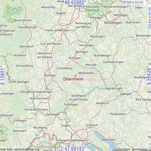
Obernheim GPS coordinates[2]
48° 9' 46.692" North, 8° 51' 40.068" East
| Map corner | latitude | longitude |
|---|---|---|
| Upper-left | 48.62982°, | 8.15801° |
| Center: | 48.16297°, | 8.86113° |
| Lower-right: | 47.69183°, | 9.56426° |
| Map W x H: | 104.3×104.3 km | = 64.8×64.8mi |
| max Lat: | 55.01917° ⇑93.2% North |
| Obernheim: | 48.16297° |
| min Lat: | ⇓6.8% South 47.40724° |
| min Long | Obernheim | max Long |
| 5.92978° | 8.86113° | 14.98853° |
| W 32.8%⇐ | ⇒67.2% E |
Elevation
Elevation of Obernheim is 902 m = 2959 ft, and this is 652.9 m = 2142 ft above average elevation for this country.
| Max E: |
1256 m = 4121 ft | 0.2% |
| Obernheim | 902 m 2959 ft | |
| Avg. | 249.1 m = 817 ft | |
Min E: |
-5 m = -16 ft | 99.8% |
See also: Germany elevation on elevation.city.
Geographical zone
Obernheim is located in North temperate zone (between Tropic of Cancer and the Arctic Circle). Distance of this North polar circle is 2046 km =1271.3 mi to North.| Distance of | km | miles | from Obernheim |
|---|---|---|---|
| North Pole | 4651.8 | 2890.5 | to North |
| Arctic Circle | 2046 | 1271.3 | to North |
| Tropic Cancer | 2749.3 | 1708.3 | to South |
| Equator | 5355.2 | 3327.6 | to South |


Nearby cities:
15 places around Obernheim: (largest is in red/bold)
• Bubsheim
5.5 km =3.4 mi,  201°
201°
• Böttingen
8.3 km =5.2 mi,  212°
212°
• Deilingen
5.8 km =3.6 mi,  282°
282°
• Dotternhausen
8.9 km =5.5 mi,  324°
324°
• Egesheim
5.1 km =3.2 mi,  183°
183°
• Gosheim
8.5 km =5.3 mi,  248°
248°
• Hausen am Tann
4.3 km =2.7 mi,  334°
334°
• Königsheim
7 km =4.3 mi, 176°
• Meßstetten
8.1 km =5 mi,  73°
73°
• Nusplingen
4.1 km =2.5 mi,  146°
146°
• Ratshausen
6 km =3.7 mi,  304°
304°
• Reichenbach am Heuberg
3.4 km =2.1 mi,  194°
194°
• Schömberg
9.2 km =5.7 mi, 304°
• Wehingen
5.5 km =3.4 mi, 249°
• Weilen unter den Rinnen
7.7 km =4.8 mi,  292°
292°
Sources, notices
• [Note1] Compared only with cities in Germany existing in our database
• [Src1] Map data: © OpenStreetMap contributors (CC-BY-SA)
• [Src2] Other city data from geonames.org with taken over terms of usage.
• [Src3] Geographical zone / Annual Mean Temperature by Robert A. Rohde @ Wikipedia
