Nirmsdorf geodata
Nirmsdorf (Thuringia) is a seat of a fourth-order administrative division; located in Germany in Europe/Berlin (GMT+2) time zone. With population of 90 people, there are 10876 cities with bigger population in this country. Compared to other cities in Germany, 59.8% of cities are located further ↓South; 73.8% of cities are located further ←West and 54% of cities have higher elevation than Nirmsdorf. Note1


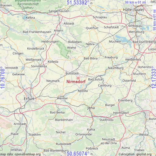
Nirmsdorf GPS coordinates[2]
51° 5' 39.984" North, 11° 28' 12.72" East
| Map corner | latitude | longitude |
|---|---|---|
| Upper-left | 51.53392°, | 10.76708° |
| Center: | 51.09444°, | 11.4702° |
| Lower-right: | 50.65074°, | 12.17333° |
| Map W x H: | 98.2×98.2 km | = 61×61mi |
| max Lat: | 55.01917° ⇑40.2% North |
| Nirmsdorf: | 51.09444° |
| min Lat: | ⇓59.8% South 47.40724° |
| min Long | Nirmsdorf | max Long |
| 5.92978° | 11.4702° | 14.98853° |
| W 73.8%⇐ | ⇒26.2% E |
Elevation
Elevation of Nirmsdorf is 197 m = 646 ft, and this is 52.1 m = 171 ft below average elevation for this country.
| Max E: |
1256 m = 4121 ft | 54% |
| Avg. | 249.1 m = 817 ft | |
| Nirmsdorf | 197 m = 646 ft | |
Min E: |
-5 m = -16 ft | 46% |
See also: Germany elevation on elevation.city.
Geographical zone
Nirmsdorf is located in North temperate zone (between Tropic of Cancer and the Arctic Circle). Distance of this North polar circle is 1720 km =1068.8 mi to North.| Distance of | km | miles | from Nirmsdorf |
|---|---|---|---|
| North Pole | 4325.9 | 2688 | to North |
| Arctic Circle | 1720 | 1068.8 | to North |
| Tropic Cancer | 3075.3 | 1910.9 | to South |
| Equator | 5681.2 | 3530.1 | to South |


Nearby cities:
15 places around Nirmsdorf: (largest is in red/bold)
• Buttstädt
4.8 km =3 mi,  309°
309°
• Goldbach
6 km =3.7 mi,  205°
205°
• Herrengosserstedt
5.4 km =3.4 mi,  4°
4°
• Ködderitzsch
2.4 km =1.5 mi,  120°
120°
• Liebstedt
7 km =4.3 mi,  224°
224°
• Mattstedt
5.9 km =3.7 mi,  146°
146°
• Niederreißen
4.2 km =2.6 mi,  276°
276°
• Niederroßla
6.9 km =4.3 mi,  172°
172°
• Oberreißen
4.1 km =2.5 mi,  258°
258°
• Pfiffelbach
4.2 km =2.6 mi, 207°
• Rannstedt
5.7 km =3.5 mi,  102°
102°
• Rohrbach
5.8 km =3.6 mi,  237°
237°
• Rudersdorf
1.5 km =0.9 mi,  293°
293°
• Wickerstedt
6.3 km =3.9 mi,  127°
127°
• Willerstedt
1.3 km =0.8 mi,  247°
247°
Sources, notices
• [Note1] Compared only with cities in Germany existing in our database
• [Src1] Map data: © OpenStreetMap contributors (CC-BY-SA)
• [Src2] Other city data from geonames.org with taken over terms of usage.
• [Src3] Geographical zone / Annual Mean Temperature by Robert A. Rohde @ Wikipedia
