Wickerstedt geodata
Wickerstedt (Thuringia) is a populated place; located in Germany in Europe/Berlin (GMT+2) time zone. With population of 882 people, there are 7584 cities with bigger population in this country. Compared to other cities in Germany, 59.2% of cities are located further ↓South; 74.9% of cities are located further ←West and 59.6% of cities have higher elevation than Wickerstedt. Note1


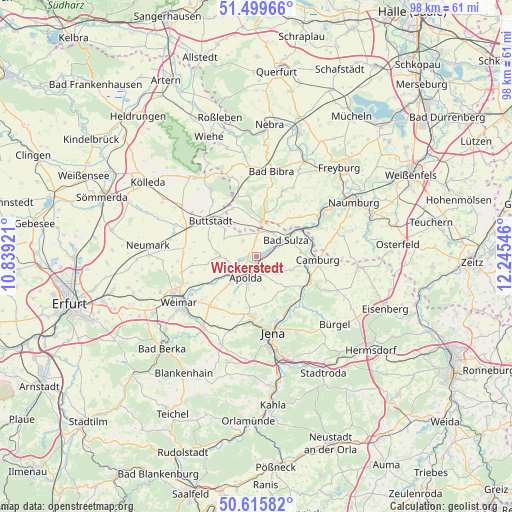
Wickerstedt GPS coordinates[2]
51° 3' 35.46" North, 11° 32' 32.388" East
| Map corner | latitude | longitude |
|---|---|---|
| Upper-left | 51.49966°, | 10.83921° |
| Center: | 51.05985°, | 11.54233° |
| Lower-right: | 50.61582°, | 12.24546° |
| Map W x H: | 98.3×98.3 km | = 61.1×61.1mi |
| max Lat: | 55.01917° ⇑40.8% North |
| Wickerstedt: | 51.05985° |
| min Lat: | ⇓59.2% South 47.40724° |
| min Long | Wickerstedt | max Long |
| 5.92978° | 11.54233° | 14.98853° |
| W 74.9%⇐ | ⇒25.1% E |
Elevation
Elevation of Wickerstedt is 156 m = 512 ft, and this is 93.1 m = 305 ft below average elevation for this country.
| Max E: |
1256 m = 4121 ft | 59.6% |
| Avg. | 249.1 m = 817 ft | |
| Wickerstedt | 156 m = 512 ft | |
Min E: |
-5 m = -16 ft | 40.4% |
See also: Germany elevation on elevation.city.
Geographical zone
Wickerstedt is located in North temperate zone (between Tropic of Cancer and the Arctic Circle). Distance of this North polar circle is 1723.9 km =1071.2 mi to North.| Distance of | km | miles | from Wickerstedt |
|---|---|---|---|
| North Pole | 4329.7 | 2690.4 | to North |
| Arctic Circle | 1723.9 | 1071.2 | to North |
| Tropic Cancer | 3071.4 | 1908.5 | to South |
| Equator | 5677.3 | 3527.7 | to South |


Nearby cities:
15 places around Wickerstedt: (largest is in red/bold)
• Apolda
4.2 km =2.6 mi,  205°
205°
• Bad Sulza
6.6 km =4.1 mi,  60°
60°
• Eberstedt
3 km =1.9 mi, 58°
• Eckartsberga
7.2 km =4.5 mi,  10°
10°
• Goldbach
7.8 km =4.8 mi,  258°
258°
• Hainichen
8.4 km =5.2 mi,  142°
142°
• Ködderitzsch
3.9 km =2.4 mi,  311°
311°
• Mattstedt
2.1 km =1.3 mi,  238°
238°
• Niederroßla
5.1 km =3.2 mi,  234°
234°
• Nirmsdorf
6.3 km =3.9 mi, 307°
• Pfiffelbach
7 km =4.3 mi,  271°
271°
• Rannstedt
2.7 km =1.7 mi, 11°
• Rudersdorf
7.8 km =4.8 mi,  304°
304°
• Schmiedehausen
8.7 km =5.4 mi,  85°
85°
• Willerstedt
7.1 km =4.4 mi, 298°
Sources, notices
• [Note1] Compared only with cities in Germany existing in our database
• [Src1] Map data: © OpenStreetMap contributors (CC-BY-SA)
• [Src2] Other city data from geonames.org with taken over terms of usage.
• [Src3] Geographical zone / Annual Mean Temperature by Robert A. Rohde @ Wikipedia
