Rannstedt geodata
Rannstedt (Thuringia) is a seat of a fourth-order administrative division; located in Germany in Europe/Berlin (GMT+2) time zone. With population of 194 people, there are 10503 cities with bigger population in this country. Compared to other cities in Germany, 59.5% of cities are located further ↓South; 75% of cities are located further ←West and 51.9% of cities have higher elevation than Rannstedt. Note1


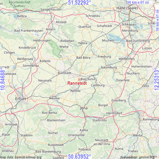
Rannstedt GPS coordinates[2]
51° 4' 59.988" North, 11° 33' 0" East
| Map corner | latitude | longitude |
|---|---|---|
| Upper-left | 51.52292°, | 10.84688° |
| Center: | 51.08333°, | 11.55° |
| Lower-right: | 50.63952°, | 12.25313° |
| Map W x H: | 98.2×98.2 km | = 61×61mi |
| max Lat: | 55.01917° ⇑40.5% North |
| Rannstedt: | 51.08333° |
| min Lat: | ⇓59.5% South 47.40724° |
| min Long | Rannstedt | max Long |
| 5.92978° | 11.55° | 14.98853° |
| W 75%⇐ | ⇒25% E |
Elevation
Elevation of Rannstedt is 212 m = 696 ft, and this is 37.1 m = 122 ft below average elevation for this country.
| Max E: |
1256 m = 4121 ft | 51.9% |
| Avg. | 249.1 m = 817 ft | |
| Rannstedt | 212 m = 696 ft | |
Min E: |
-5 m = -16 ft | 48.1% |
See also: Germany elevation on elevation.city.
Geographical zone
Rannstedt is located in North temperate zone (between Tropic of Cancer and the Arctic Circle). Distance of this North polar circle is 1721.2 km =1069.5 mi to North.| Distance of | km | miles | from Rannstedt |
|---|---|---|---|
| North Pole | 4327.1 | 2688.7 | to North |
| Arctic Circle | 1721.2 | 1069.5 | to North |
| Tropic Cancer | 3074 | 1910.1 | to South |
| Equator | 5679.9 | 3529.3 | to South |


Nearby cities:
15 places around Rannstedt: (largest is in red/bold)
• Apolda
6.8 km =4.2 mi,  200°
200°
• Bad Sulza
5.3 km =3.3 mi,  82°
82°
• Eberstedt
2.3 km =1.4 mi,  117°
117°
• Eckartsberga
4.6 km =2.9 mi,  9°
9°
• Herrengosserstedt
8.3 km =5.2 mi,  322°
322°
• Ködderitzsch
3.5 km =2.2 mi,  270°
270°
• Mattstedt
4.4 km =2.7 mi,  212°
212°
• Niederroßla
7.3 km =4.5 mi,  219°
219°
• Nirmsdorf
5.7 km =3.5 mi,  282°
282°
• Pfiffelbach
7.9 km =4.9 mi,  251°
251°
• Rudersdorf
7.2 km =4.5 mi, 284°
• Schmiedehausen
8.4 km =5.2 mi,  102°
102°
• Taugwitz
7.6 km =4.7 mi,  51°
51°
• Wickerstedt
2.7 km =1.7 mi,  191°
191°
• Willerstedt
6.8 km =4.2 mi, 276°
Sources, notices
• [Note1] Compared only with cities in Germany existing in our database
• [Src1] Map data: © OpenStreetMap contributors (CC-BY-SA)
• [Src2] Other city data from geonames.org with taken over terms of usage.
• [Src3] Geographical zone / Annual Mean Temperature by Robert A. Rohde @ Wikipedia
