Neustadt in Holstein geodata
Neustadt in Holstein (Schleswig-Holstein) is a populated place; located in Germany in Europe/Berlin (GMT+2) time zone. With population of 16,176 people, there are 985 cities with bigger population in this country. Compared to other cities in Germany, 94% of cities are located further ↓South; 64.2% of cities are located further ←West and 93.9% of cities have higher elevation than Neustadt in Holstein. Note1
Administrative division(s):
- Level 1: Schleswig-Holstein
- Level 3: Kreis Ostholstein
- Level 4: Neustadt in Holstein


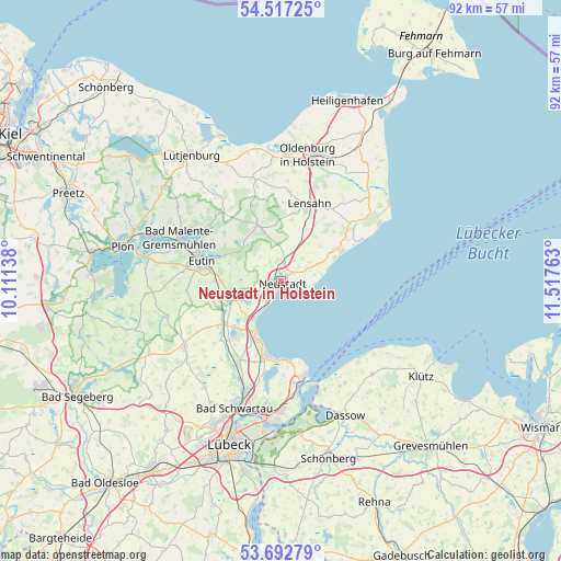
Neustadt in Holstein GPS coordinates[2]
54° 6' 25.452" North, 10° 48' 52.2" East
| Map corner | latitude | longitude |
|---|---|---|
| Upper-left | 54.51725°, | 10.11138° |
| Center: | 54.10707°, | 10.8145° |
| Lower-right: | 53.69279°, | 11.51763° |
| Map W x H: | 91.7×91.7 km | = 57×57mi |
| max Lat: | 55.01917° ⇑6% North |
| Neustadt in Holstein: | 54.10707° |
| min Lat: | ⇓94% South 47.40724° |
| min Long | Neustadt in Hol | max Long |
| 5.92978° | 10.8145° | 14.98853° |
| W 64.2%⇐ | ⇒35.8% E |
Elevation
Elevation of Neustadt in Holstein is 11 m = 36 ft, and this is 238.1 m = 781 ft below average elevation for this country.
| Max E: |
1256 m = 4121 ft | 93.9% |
| Avg. | 249.1 m = 817 ft | |
| Neustadt in Holstein | 11 m = 36 ft | |
Min E: |
-5 m = -16 ft | 6.1% |
See also: Germany elevation on elevation.city.
Geographical zone
Neustadt in Holstein is located in North temperate zone (between Tropic of Cancer and the Arctic Circle). Distance of this North polar circle is 1385 km =860.6 mi to North.| Distance of | km | miles | from Neustadt in Holstein |
|---|---|---|---|
| North Pole | 3990.9 | 2479.8 | to North |
| Arctic Circle | 1385 | 860.6 | to North |
| Tropic Cancer | 3410.2 | 2119 | to South |
| Equator | 6016.1 | 3738.2 | to South |


Nearby cities:
15 places around Neustadt in Holstein: (largest is in red/bold)
• Altenkrempe
3.2 km =2 mi,  22°
22°
• Beschendorf
9.1 km =5.7 mi, 21°
• Eutin
14 km =8.7 mi,  285°
285°
• Grömitz
11 km =6.8 mi,  64°
64°
• Kabelhorst
13.9 km =8.6 mi,  28°
28°
• Kasseedorf
9.2 km =5.7 mi,  316°
316°
• Kirchnüchel
13.4 km =8.3 mi, 320°
• Lensahn
13 km =8.1 mi, 20°
• Manhagen
12.3 km =7.6 mi, 32°
• Scharbeutz
9.2 km =5.7 mi,  207°
207°
• Schashagen
5.4 km =3.4 mi, 56°
• Schönwalde am Bungsberg
9.5 km =5.9 mi,  333°
333°
• Sierksdorf
5.5 km =3.4 mi, 214°
• Süsel
7.9 km =4.9 mi,  248°
248°
• Timmendorfer Strand
12.7 km =7.9 mi,  191°
191°
Sources, notices
• [Note1] Compared only with cities in Germany existing in our database
• [Src1] Map data: © OpenStreetMap contributors (CC-BY-SA)
• [Src2] Other city data from geonames.org with taken over terms of usage.
• [Src3] Geographical zone / Annual Mean Temperature by Robert A. Rohde @ Wikipedia
