Eutin geodata
Eutin (Schleswig-Holstein) is a seat of a third-order administrative division; located in Germany in Europe/Berlin (GMT+2) time zone. With population of 16,984 people, there are 935 cities with bigger population in this country. Compared to other cities in Germany, 94.4% of cities are located further ↓South; 60.9% of cities are located further ←West and 81% of cities have higher elevation than Eutin. Note1


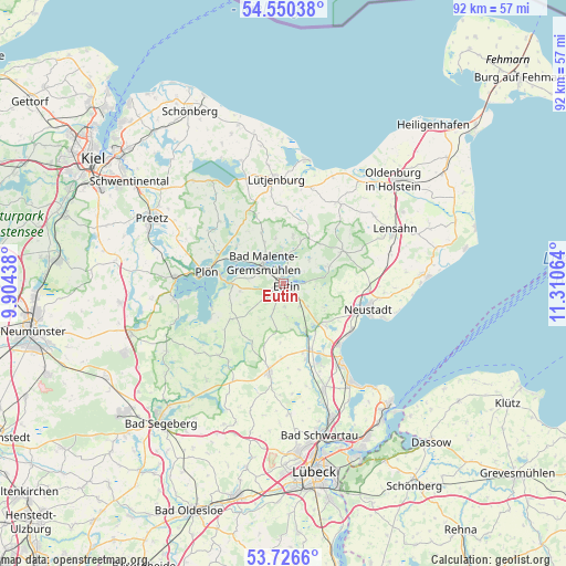
Eutin GPS coordinates[2]
54° 8' 25.944" North, 10° 36' 27.036" East
| Map corner | latitude | longitude |
|---|---|---|
| Upper-left | 54.55038°, | 9.90438° |
| Center: | 54.14054°, | 10.60751° |
| Lower-right: | 53.7266°, | 11.31064° |
| Map W x H: | 91.6×91.6 km | = 56.9×56.9mi |
| max Lat: | 55.01917° ⇑5.6% North |
| Eutin: | 54.14054° |
| min Lat: | ⇓94.4% South 47.40724° |
| min Long | Eutin | max Long |
| 5.92978° | 10.60751° | 14.98853° |
| W 60.9%⇐ | ⇒39.1% E |
Elevation
Elevation of Eutin is 44 m = 144 ft, and this is 205.1 m = 673 ft below average elevation for this country.
| Max E: |
1256 m = 4121 ft | 81% |
| Avg. | 249.1 m = 817 ft | |
| Eutin | 44 m = 144 ft | |
Min E: |
-5 m = -16 ft | 19% |
See also: Germany elevation on elevation.city.
Geographical zone
Eutin is located in North temperate zone (between Tropic of Cancer and the Arctic Circle). Distance of this North polar circle is 1381.3 km =858.3 mi to North.| Distance of | km | miles | from Eutin |
|---|---|---|---|
| North Pole | 3987.2 | 2477.5 | to North |
| Arctic Circle | 1381.3 | 858.3 | to North |
| Tropic Cancer | 3413.9 | 2121.3 | to South |
| Equator | 6019.9 | 3740.6 | to South |


Nearby cities:
15 places around Eutin: (largest is in red/bold)
• Bosau
12.2 km =7.6 mi,  247°
247°
• Bösdorf
8.2 km =5.1 mi,  277°
277°
• Dannau
11.9 km =7.4 mi,  339°
339°
• Glasau
11.7 km =7.3 mi,  210°
210°
• Grebin
9.6 km =6 mi,  313°
313°
• Högsdorf
12.2 km =7.6 mi,  2°
2°
• Kasseedorf
7.7 km =4.8 mi,  67°
67°
• Kirchnüchel
8.3 km =5.2 mi,  36°
36°
• Kletkamp
12.3 km =7.6 mi,  7°
7°
• Malente
4.7 km =2.9 mi,  318°
318°
• Neukirchen
9 km =5.6 mi, 337°
• Plön
12.2 km =7.6 mi, 281°
• Rathjensdorf
12.3 km =7.6 mi,  292°
292°
• Schönwalde am Bungsberg
10.4 km =6.5 mi,  62°
62°
• Süsel
9 km =5.6 mi,  136°
136°
Sources, notices
• [Note1] Compared only with cities in Germany existing in our database
• [Src1] Map data: © OpenStreetMap contributors (CC-BY-SA)
• [Src2] Other city data from geonames.org with taken over terms of usage.
• [Src3] Geographical zone / Annual Mean Temperature by Robert A. Rohde @ Wikipedia
