Kirchnüchel geodata
Kirchnüchel (Schleswig-Holstein) is a seat of a fourth-order administrative division; located in Germany in Europe/Berlin (GMT+2) time zone. With population of 181 people, there are 10555 cities with bigger population in this country. Compared to other cities in Germany, 95.1% of cities are located further ↓South; 62.2% of cities are located further ←West and 66.7% of cities have higher elevation than Kirchnüchel. Note1


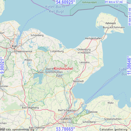
Kirchnüchel GPS coordinates[2]
54° 12' 0" North, 10° 40' 59.988" East
| Map corner | latitude | longitude |
|---|---|---|
| Upper-left | 54.60925°, | 9.98021° |
| Center: | 54.2°, | 10.68333° |
| Lower-right: | 53.78665°, | 11.38646° |
| Map W x H: | 91.5×91.5 km | = 56.9×56.9mi |
| max Lat: | 55.01917° ⇑4.9% North |
| Kirchnüchel: | 54.2° |
| min Lat: | ⇓95.1% South 47.40724° |
| min Long | Kirchnüchel | max Long |
| 5.92978° | 10.68333° | 14.98853° |
| W 62.2%⇐ | ⇒37.8% E |
Elevation
Elevation of Kirchnüchel is 110 m = 361 ft, and this is 139.1 m = 456 ft below average elevation for this country.
| Max E: |
1256 m = 4121 ft | 66.7% |
| Avg. | 249.1 m = 817 ft | |
| Kirchnüchel | 110 m = 361 ft | |
Min E: |
-5 m = -16 ft | 33.3% |
See also: Germany elevation on elevation.city.
Geographical zone
Kirchnüchel is located in North temperate zone (between Tropic of Cancer and the Arctic Circle). Distance of this North polar circle is 1374.7 km =854.2 mi to North.| Distance of | km | miles | from Kirchnüchel |
|---|---|---|---|
| North Pole | 3980.6 | 2473.4 | to North |
| Arctic Circle | 1374.7 | 854.2 | to North |
| Tropic Cancer | 3420.6 | 2125.5 | to South |
| Equator | 6026.5 | 3744.7 | to South |


Nearby cities:
15 places around Kirchnüchel: (largest is in red/bold)
• Beschendorf
12.1 km =7.5 mi,  98°
98°
• Blekendorf
9.3 km =5.8 mi,  349°
349°
• Dannau
10.2 km =6.3 mi,  296°
296°
• Eutin
8.3 km =5.2 mi,  216°
216°
• Grebin
11.9 km =7.4 mi,  270°
270°
• Harmsdorf
10.7 km =6.6 mi,  65°
65°
• Helmstorf
10.7 km =6.6 mi,  329°
329°
• Högsdorf
7 km =4.3 mi,  322°
322°
• Kasseedorf
4.3 km =2.7 mi,  149°
149°
• Kletkamp
6.4 km =4 mi, 329°
• Lütjenburg
11.9 km =7.4 mi, 329°
• Malente
8.6 km =5.3 mi,  249°
249°
• Neukirchen
8.6 km =5.3 mi,  280°
280°
• Schönwalde am Bungsberg
4.7 km =2.9 mi,  113°
113°
• Wangels
9.2 km =5.7 mi,  36°
36°
Sources, notices
• [Note1] Compared only with cities in Germany existing in our database
• [Src1] Map data: © OpenStreetMap contributors (CC-BY-SA)
• [Src2] Other city data from geonames.org with taken over terms of usage.
• [Src3] Geographical zone / Annual Mean Temperature by Robert A. Rohde @ Wikipedia
