Neuengönna geodata
Neuengönna (Thuringia) is a seat of a fourth-order administrative division; located in Germany in Europe/Berlin (GMT+2) time zone. With population of 698 people, there are 8324 cities with bigger population in this country. Compared to other cities in Germany, 57.8% of cities are located further ↓South; 76.4% of cities are located further ←West and 55.8% of cities have lower elevation than Neuengönna. Note1


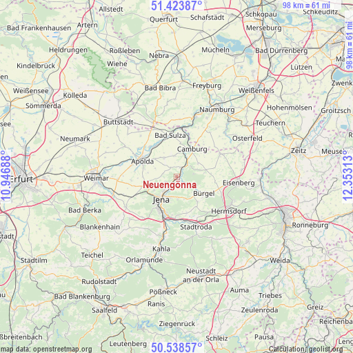
Neuengönna GPS coordinates[2]
50° 58' 59.988" North, 11° 39' 0" East
| Map corner | latitude | longitude |
|---|---|---|
| Upper-left | 51.42387°, | 10.94688° |
| Center: | 50.98333°, | 11.65° |
| Lower-right: | 50.53857°, | 12.35313° |
| Map W x H: | 98.4×98.4 km | = 61.1×61.1mi |
| max Lat: | 55.01917° ⇑42.2% North |
| Neuengönna: | 50.98333° |
| min Lat: | ⇓57.8% South 47.40724° |
| min Long | Neuengönna | max Long |
| 5.92978° | 11.65° | 14.98853° |
| W 76.4%⇐ | ⇒23.6% E |
Elevation
Elevation of Neuengönna is 264 m = 866 ft, and this is 14.9 m = 49 ft above average elevation for this country.
| Max E: |
1256 m = 4121 ft | 44.2% |
| Neuengönna | 264 m 866 ft | |
| Avg. | 249.1 m = 817 ft | |
Min E: |
-5 m = -16 ft | 55.8% |
See also: Germany elevation on elevation.city.
Geographical zone
Neuengönna is located in North temperate zone (between Tropic of Cancer and the Arctic Circle). Distance of this North polar circle is 1732.4 km =1076.5 mi to North.| Distance of | km | miles | from Neuengönna |
|---|---|---|---|
| North Pole | 4338.2 | 2695.6 | to North |
| Arctic Circle | 1732.4 | 1076.5 | to North |
| Tropic Cancer | 3062.9 | 1903.2 | to South |
| Equator | 5668.8 | 3522.4 | to South |


Nearby cities:
15 places around Neuengönna: (largest is in red/bold)
• Bürgel
8.7 km =5.4 mi,  121°
121°
• Dornburg
2.8 km =1.7 mi,  19°
19°
• Frauenprießnitz
6.9 km =4.3 mi,  57°
57°
• Golmsdorf
2.2 km =1.4 mi,  147°
147°
• Großlöbichau
6.5 km =4 mi,  161°
161°
• Hainichen
3 km =1.9 mi,  308°
308°
• Jena
7.4 km =4.6 mi,  214°
214°
• Jenalöbnitz
5.1 km =3.2 mi,  136°
136°
• Lehesten
4.7 km =2.9 mi,  270°
270°
• Löberschütz
4 km =2.5 mi, 117°
• Nausnitz
6.9 km =4.3 mi, 122°
• Poxdorf
7.2 km =4.5 mi,  104°
104°
• Tautenburg
5 km =3.1 mi,  68°
68°
• Wichmar
6 km =3.7 mi, 22°
• Zimmern
2.2 km =1.4 mi,  327°
327°
Sources, notices
• [Note1] Compared only with cities in Germany existing in our database
• [Src1] Map data: © OpenStreetMap contributors (CC-BY-SA)
• [Src2] Other city data from geonames.org with taken over terms of usage.
• [Src3] Geographical zone / Annual Mean Temperature by Robert A. Rohde @ Wikipedia
