Jena geodata
Jena (Thuringia) is a seat of a third-order administrative division; located in Germany in Europe/Berlin (GMT+2) time zone. With population of 104,712 people, there are 91 cities with bigger population in this country. Compared to other cities in Germany, 56.7% of cities are located further ↓South; 75.6% of cities are located further ←West and 60.4% of cities have higher elevation than Jena. Note1


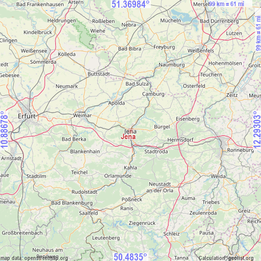
Jena GPS coordinates[2]
50° 55' 43.608" North, 11° 35' 23.64" East
| Map corner | latitude | longitude |
|---|---|---|
| Upper-left | 51.36984°, | 10.88678° |
| Center: | 50.92878°, | 11.5899° |
| Lower-right: | 50.4835°, | 12.29303° |
| Map W x H: | 98.6×98.6 km | = 61.3×61.3mi |
| max Lat: | 55.01917° ⇑43.3% North |
| Jena: | 50.92878° |
| min Lat: | ⇓56.7% South 47.40724° |
| min Long | Jena | max Long |
| 5.92978° | 11.5899° | 14.98853° |
| W 75.6%⇐ | ⇒24.4% E |
Elevation
Elevation of Jena is 149 m = 489 ft, and this is 100.1 m = 328 ft below average elevation for this country.
| Max E: |
1256 m = 4121 ft | 60.4% |
| Avg. | 249.1 m = 817 ft | |
| Jena | 149 m = 489 ft | |
Min E: |
-5 m = -16 ft | 39.6% |
See also: Jena elevation on elevation.city.
Geographical zone
Jena is located in North temperate zone (between Tropic of Cancer and the Arctic Circle). Distance of this North polar circle is 1738.4 km =1080.2 mi to North.| Distance of | km | miles | from Jena |
|---|---|---|---|
| North Pole | 4344.3 | 2699.4 | to North |
| Arctic Circle | 1738.4 | 1080.2 | to North |
| Tropic Cancer | 3056.8 | 1899.4 | to South |
| Equator | 5662.7 | 3518.6 | to South |


Nearby cities:
15 places around Jena: (largest is in red/bold)
• Bucha
7.2 km =4.5 mi,  225°
225°
• Döbritschen
8.1 km =5 mi,  262°
262°
• Golmsdorf
6.8 km =4.2 mi,  51°
51°
• Großlöbichau
6.3 km =3.9 mi,  90°
90°
• Großschwabhausen
7.5 km =4.7 mi,  273°
273°
• Hainichen
8.1 km =5 mi,  13°
13°
• Jenalöbnitz
8.1 km =5 mi,  72°
72°
• Laasdorf
8.6 km =5.3 mi,  137°
137°
• Lehesten
6.1 km =3.8 mi,  355°
355°
• Löberschütz
8.8 km =5.5 mi,  61°
61°
• Neuengönna
7.4 km =4.6 mi,  34°
34°
• Schlöben
7.9 km =4.9 mi,  119°
119°
• Sulza
7.2 km =4.5 mi,  164°
164°
• Zimmern
8.5 km =5.3 mi,  21°
21°
• Zöllnitz
7.1 km =4.4 mi,  149°
149°
Sources, notices
• [Note1] Compared only with cities in Germany existing in our database
• [Src1] Map data: © OpenStreetMap contributors (CC-BY-SA)
• [Src2] Other city data from geonames.org with taken over terms of usage.
• [Src3] Geographical zone / Annual Mean Temperature by Robert A. Rohde @ Wikipedia
