Münster geodata
Münster (Bavaria) is a populated place; located in Germany in Europe/Berlin (GMT+2) time zone. With population of 1,078 people, there are 6918 cities with bigger population in this country. Compared to other cities in Germany, 92.3% of cities are located further ↑North; 61.4% of cities are located further ←West and 91.3% of cities have lower elevation than Münster. Note1
Administrative division(s):
- Level 1: Bavaria
- Level 2: Swabia
- Level 3: Landkreis Augsburg
- Level 4: Mickhausen


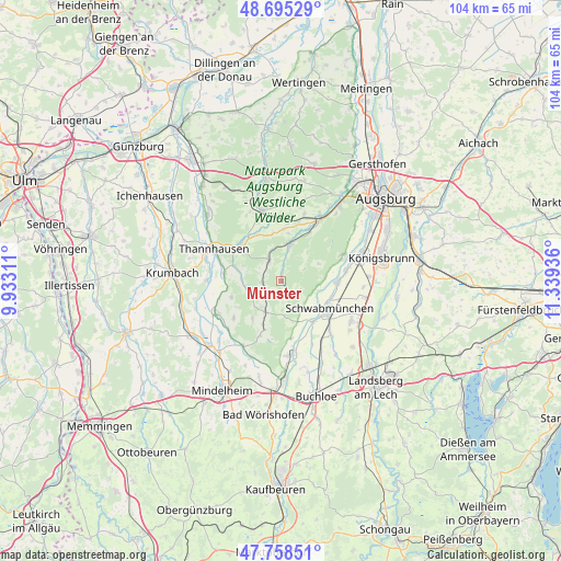
Münster GPS coordinates[2]
48° 13' 44.544" North, 10° 38' 10.428" East
| Map corner | latitude | longitude |
|---|---|---|
| Upper-left | 48.69529°, | 9.93311° |
| Center: | 48.22904°, | 10.63623° |
| Lower-right: | 47.75851°, | 11.33936° |
| Map W x H: | 104.2×104.2 km | = 64.7×64.7mi |
| max Lat: | 55.01917° ⇑92.3% North |
| Münster: | 48.22904° |
| min Lat: | ⇓7.7% South 47.40724° |
| min Long | Münster | max Long |
| 5.92978° | 10.63623° | 14.98853° |
| W 61.4%⇐ | ⇒38.6% E |
Elevation
Elevation of Münster is 532 m = 1745 ft, and this is 282.9 m = 928 ft above average elevation for this country.
| Max E: |
1256 m = 4121 ft | 8.7% |
| Münster | 532 m 1745 ft | |
| Avg. | 249.1 m = 817 ft | |
Min E: |
-5 m = -16 ft | 91.3% |
See also: Germany elevation on elevation.city.
Geographical zone
Münster is located in North temperate zone (between Tropic of Cancer and the Arctic Circle). Distance of this North polar circle is 2038.6 km =1266.7 mi to North.| Distance of | km | miles | from Münster |
|---|---|---|---|
| North Pole | 4644.5 | 2886 | to North |
| Arctic Circle | 2038.6 | 1266.7 | to North |
| Tropic Cancer | 2756.6 | 1712.9 | to South |
| Equator | 5362.6 | 3332.2 | to South |


Nearby cities:
15 places around Münster: (largest is in red/bold)
• Aichen
7.2 km =4.5 mi,  269°
269°
• Balzhausen
10.7 km =6.6 mi,  277°
277°
• Eppishausen
11.3 km =7 mi,  231°
231°
• Fischach
7 km =4.3 mi,  12°
12°
• Großaitingen
10.6 km =6.6 mi,  90°
90°
• Hiltenfingen
9.7 km =6 mi,  141°
141°
• Langenneufnach
5 km =3.1 mi,  327°
327°
• Markt Wald
11 km =6.8 mi,  201°
201°
• Mickhausen
1.4 km =0.9 mi, 11°
• Mittelneufnach
6.5 km =4 mi,  206°
206°
• Scherstetten
5.4 km =3.4 mi,  177°
177°
• Schwabmünchen
10.5 km =6.5 mi,  121°
121°
• Ustersbach
9.8 km =6.1 mi, 5°
• Walkertshofen
3.6 km =2.2 mi,  264°
264°
• Ziemetshausen
10.3 km =6.4 mi,  313°
313°
Sources, notices
• [Note1] Compared only with cities in Germany existing in our database
• [Src1] Map data: © OpenStreetMap contributors (CC-BY-SA)
• [Src2] Other city data from geonames.org with taken over terms of usage.
• [Src3] Geographical zone / Annual Mean Temperature by Robert A. Rohde @ Wikipedia
