Mickhausen geodata
Mickhausen (Bavaria) is a seat of a fourth-order administrative division; located in Germany in Europe/Berlin (GMT+2) time zone. With population of 1,367 people, there are 6147 cities with bigger population in this country. Compared to other cities in Germany, 92.1% of cities are located further ↑North; 61.5% of cities are located further ←West and 90.8% of cities have lower elevation than Mickhausen. Note1
Administrative division(s):
- Level 1: Bavaria
- Level 2: Swabia
- Level 3: Landkreis Augsburg
- Level 4: Mickhausen


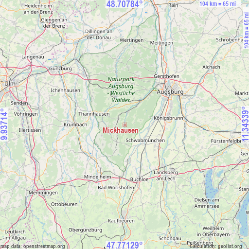
Mickhausen GPS coordinates[2]
48° 14' 30.156" North, 10° 38' 24.936" East
| Map corner | latitude | longitude |
|---|---|---|
| Upper-left | 48.70784°, | 9.93714° |
| Center: | 48.24171°, | 10.64026° |
| Lower-right: | 47.77129°, | 11.34339° |
| Map W x H: | 104.1×104.1 km | = 64.7×64.7mi |
| max Lat: | 55.01917° ⇑92.1% North |
| Mickhausen: | 48.24171° |
| min Lat: | ⇓7.9% South 47.40724° |
| min Long | Mickhausen | max Long |
| 5.92978° | 10.64026° | 14.98853° |
| W 61.5%⇐ | ⇒38.5% E |
Elevation
Elevation of Mickhausen is 524 m = 1719 ft, and this is 274.9 m = 902 ft above average elevation for this country.
| Max E: |
1256 m = 4121 ft | 9.2% |
| Mickhausen | 524 m 1719 ft | |
| Avg. | 249.1 m = 817 ft | |
Min E: |
-5 m = -16 ft | 90.8% |
See also: Germany elevation on elevation.city.
Geographical zone
Mickhausen is located in North temperate zone (between Tropic of Cancer and the Arctic Circle). Distance of this North polar circle is 2037.2 km =1265.9 mi to North.| Distance of | km | miles | from Mickhausen |
|---|---|---|---|
| North Pole | 4643.1 | 2885.1 | to North |
| Arctic Circle | 2037.2 | 1265.9 | to North |
| Tropic Cancer | 2758.1 | 1713.8 | to South |
| Equator | 5364 | 3333 | to South |


Nearby cities:
15 places around Mickhausen: (largest is in red/bold)
• Aichen
7.6 km =4.7 mi,  259°
259°
• Balzhausen
10.9 km =6.8 mi,  270°
270°
• Fischach
5.5 km =3.4 mi,  12°
12°
• Gessertshausen
11.9 km =7.4 mi,  35°
35°
• Großaitingen
10.4 km =6.5 mi,  98°
98°
• Hiltenfingen
10.7 km =6.6 mi,  147°
147°
• Kutzenhausen
11.9 km =7.4 mi,  19°
19°
• Langenneufnach
4.1 km =2.5 mi,  312°
312°
• Mittelneufnach
7.9 km =4.9 mi,  203°
203°
• Münster
1.4 km =0.9 mi,  191°
191°
• Scherstetten
6.8 km =4.2 mi,  180°
180°
• Schwabmünchen
11.1 km =6.9 mi,  128°
128°
• Ustersbach
8.4 km =5.2 mi,  4°
4°
• Walkertshofen
4.2 km =2.6 mi,  245°
245°
• Ziemetshausen
9.6 km =6 mi, 305°
Sources, notices
• [Note1] Compared only with cities in Germany existing in our database
• [Src1] Map data: © OpenStreetMap contributors (CC-BY-SA)
• [Src2] Other city data from geonames.org with taken over terms of usage.
• [Src3] Geographical zone / Annual Mean Temperature by Robert A. Rohde @ Wikipedia
