Mülverstedt geodata
Mülverstedt (Thuringia) is a seat of a fourth-order administrative division; located in Germany in Europe/Berlin (GMT+2) time zone. With population of 703 people, there are 8299 cities with bigger population in this country. Compared to other cities in Germany, 60.1% of cities are located further ↓South; 58.9% of cities are located further ←West and 50.7% of cities have higher elevation than Mülverstedt. Note1
Administrative division(s):
- Level 1: Thuringia
- Level 3: Unstrut-Hainich-Kreis
- Level 4: Unstrut-Hainich


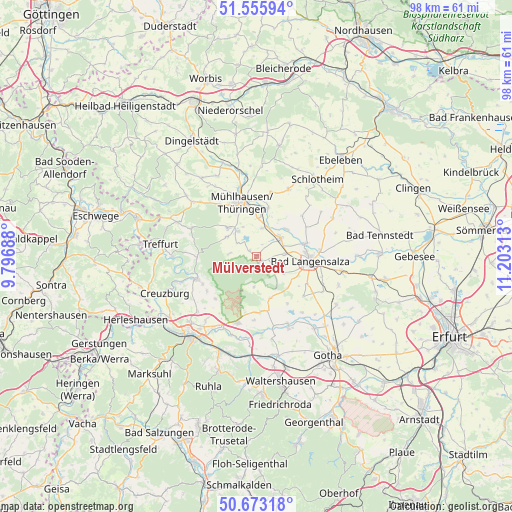
Mülverstedt GPS coordinates[2]
51° 7' 0.012" North, 10° 30' 0" East
| Map corner | latitude | longitude |
|---|---|---|
| Upper-left | 51.55594°, | 9.79688° |
| Center: | 51.11667°, | 10.5° |
| Lower-right: | 50.67318°, | 11.20313° |
| Map W x H: | 98.2×98.2 km | = 61×61mi |
| max Lat: | 55.01917° ⇑39.9% North |
| Mülverstedt: | 51.11667° |
| min Lat: | ⇓60.1% South 47.40724° |
| min Long | Mülverstedt | max Long |
| 5.92978° | 10.5° | 14.98853° |
| W 58.9%⇐ | ⇒41.1% E |
Elevation
Elevation of Mülverstedt is 220 m = 722 ft, and this is 29.1 m = 95 ft below average elevation for this country.
| Max E: |
1256 m = 4121 ft | 50.7% |
| Avg. | 249.1 m = 817 ft | |
| Mülverstedt | 220 m = 722 ft | |
Min E: |
-5 m = -16 ft | 49.3% |
See also: Germany elevation on elevation.city.
Geographical zone
Mülverstedt is located in North temperate zone (between Tropic of Cancer and the Arctic Circle). Distance of this North polar circle is 1717.5 km =1067.2 mi to North.| Distance of | km | miles | from Mülverstedt |
|---|---|---|---|
| North Pole | 4323.4 | 2686.4 | to North |
| Arctic Circle | 1717.5 | 1067.2 | to North |
| Tropic Cancer | 3077.7 | 1912.4 | to South |
| Equator | 5683.6 | 3531.6 | to South |


Nearby cities:
15 places around Mülverstedt: (largest is in red/bold)
• Altengottern
7.7 km =4.8 mi,  47°
47°
• Bad Langensalza
10.2 km =6.3 mi,  95°
95°
• Bothenheilingen
11 km =6.8 mi, 47°
• Flarchheim
2.2 km =1.4 mi,  327°
327°
• Großengottern
5.6 km =3.5 mi, 51°
• Heroldishausen
2.2 km =1.4 mi,  32°
32°
• Kammerforst
5.4 km =3.4 mi,  275°
275°
• Langula
6.9 km =4.3 mi,  302°
302°
• Mühlhausen
10.8 km =6.7 mi,  342°
342°
• Niederdorla
6 km =3.7 mi,  323°
323°
• Oberdorla
7.7 km =4.8 mi, 315°
• Oppershausen
4 km =2.5 mi, 297°
• Schönstedt
5.4 km =3.4 mi,  86°
86°
• Seebach
5.5 km =3.4 mi,  10°
10°
• Weberstedt
1.2 km =0.7 mi,  141°
141°
Sources, notices
• [Note1] Compared only with cities in Germany existing in our database
• [Src1] Map data: © OpenStreetMap contributors (CC-BY-SA)
• [Src2] Other city data from geonames.org with taken over terms of usage.
• [Src3] Geographical zone / Annual Mean Temperature by Robert A. Rohde @ Wikipedia
