Langula geodata
Langula (Thuringia) is a populated place; located in Germany in Europe/Berlin (GMT+2) time zone. With population of 1,135 people, there are 6747 cities with bigger population in this country. Compared to other cities in Germany, 60.8% of cities are located further ↓South; 57.5% of cities are located further ←West and 51.7% of cities have lower elevation than Langula. Note1


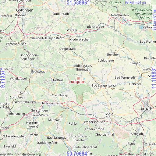
Langula GPS coordinates[2]
51° 9' 0.036" North, 10° 25' 0.12" East
| Map corner | latitude | longitude |
|---|---|---|
| Upper-left | 51.58896°, | 9.71357° |
| Center: | 51.15001°, | 10.4167° |
| Lower-right: | 50.70684°, | 11.11983° |
| Map W x H: | 98.1×98.1 km | = 61×61mi |
| max Lat: | 55.01917° ⇑39.2% North |
| Langula: | 51.15001° |
| min Lat: | ⇓60.8% South 47.40724° |
| min Long | Langula | max Long |
| 5.92978° | 10.4167° | 14.98853° |
| W 57.5%⇐ | ⇒42.5% E |
Elevation
Elevation of Langula is 238 m = 781 ft, and this is 11.1 m = 36 ft below average elevation for this country.
| Max E: |
1256 m = 4121 ft | 48.3% |
| Avg. | 249.1 m = 817 ft | |
| Langula | 238 m = 781 ft | |
Min E: |
-5 m = -16 ft | 51.7% |
See also: Germany elevation on elevation.city.
Geographical zone
Langula is located in North temperate zone (between Tropic of Cancer and the Arctic Circle). Distance of this North polar circle is 1713.8 km =1064.9 mi to North.| Distance of | km | miles | from Langula |
|---|---|---|---|
| North Pole | 4319.7 | 2684.1 | to North |
| Arctic Circle | 1713.8 | 1064.9 | to North |
| Tropic Cancer | 3081.4 | 1914.7 | to South |
| Equator | 5687.3 | 3533.9 | to South |


Nearby cities:
15 places around Langula: (largest is in red/bold)
• Flarchheim
5 km =3.1 mi,  111°
111°
• Großengottern
10.2 km =6.3 mi,  91°
91°
• Hallungen
6.1 km =3.8 mi,  252°
252°
• Heroldishausen
7.2 km =4.5 mi,  104°
104°
• Heyerode
6.9 km =4.3 mi,  283°
283°
• Kammerforst
3.2 km =2 mi,  171°
171°
• Mihla
10.1 km =6.3 mi,  215°
215°
• Mühlhausen
7 km =4.3 mi,  20°
20°
• Mülverstedt
6.9 km =4.3 mi,  122°
122°
• Nazza
6.9 km =4.3 mi,  235°
235°
• Niederdorla
2.5 km =1.6 mi,  62°
62°
• Oberdorla
1.8 km =1.1 mi,  11°
11°
• Oppershausen
3 km =1.9 mi,  128°
128°
• Seebach
7 km =4.3 mi,  76°
76°
• Weberstedt
8 km =5 mi, 125°
Sources, notices
• [Note1] Compared only with cities in Germany existing in our database
• [Src1] Map data: © OpenStreetMap contributors (CC-BY-SA)
• [Src2] Other city data from geonames.org with taken over terms of usage.
• [Src3] Geographical zone / Annual Mean Temperature by Robert A. Rohde @ Wikipedia
