Mühlhausen geodata
Mühlhausen (Thuringia) is a seat of a third-order administrative division; located in Germany in Europe/Berlin (GMT+2) time zone. With population of 38,108 people, there are 347 cities with bigger population in this country. Compared to other cities in Germany, 61.7% of cities are located further ↓South; 58.2% of cities are located further ←West and 50.5% of cities have higher elevation than Mühlhausen. Note1
Administrative division(s):
- Level 1: Thuringia
- Level 3: Unstrut-Hainich-Kreis
- Level 4: Mühlhausen/Thüringen


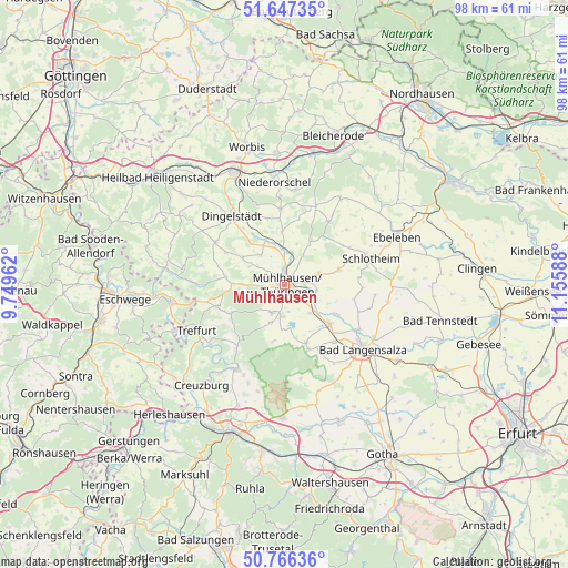
Mühlhausen GPS coordinates[2]
51° 12' 32.256" North, 10° 27' 9.9" East
| Map corner | latitude | longitude |
|---|---|---|
| Upper-left | 51.64735°, | 9.74962° |
| Center: | 51.20896°, | 10.45275° |
| Lower-right: | 50.76636°, | 11.15588° |
| Map W x H: | 98×98 km | = 60.9×60.9mi |
| max Lat: | 55.01917° ⇑38.3% North |
| Mühlhausen: | 51.20896° |
| min Lat: | ⇓61.7% South 47.40724° |
| min Long | Mühlhausen | max Long |
| 5.92978° | 10.45275° | 14.98853° |
| W 58.2%⇐ | ⇒41.8% E |
Elevation
Elevation of Mühlhausen is 221 m = 725 ft, and this is 28.1 m = 92 ft below average elevation for this country.
| Max E: |
1256 m = 4121 ft | 50.5% |
| Avg. | 249.1 m = 817 ft | |
| Mühlhausen | 221 m = 725 ft | |
Min E: |
-5 m = -16 ft | 49.5% |
See also: Germany elevation on elevation.city.
Geographical zone
Mühlhausen is located in North temperate zone (between Tropic of Cancer and the Arctic Circle). Distance of this North polar circle is 1707.3 km =1060.9 mi to North.| Distance of | km | miles | from Mühlhausen |
|---|---|---|---|
| North Pole | 4313.2 | 2680.1 | to North |
| Arctic Circle | 1707.3 | 1060.9 | to North |
| Tropic Cancer | 3088 | 1918.8 | to South |
| Equator | 5693.9 | 3538 | to South |


Nearby cities:
15 places around Mühlhausen: (largest is in red/bold)
• Altengottern
10.2 km =6.3 mi,  119°
119°
• Anrode
10.5 km =6.5 mi,  307°
307°
• Flarchheim
8.7 km =5.4 mi,  165°
165°
• Großengottern
10.2 km =6.3 mi,  131°
131°
• Heroldishausen
9.5 km =5.9 mi,  152°
152°
• Heyerode
10.5 km =6.5 mi,  241°
241°
• Kammerforst
9.9 km =6.2 mi,  191°
191°
• Körner
9.8 km =6.1 mi,  75°
75°
• Langula
7 km =4.3 mi,  200°
200°
• Mülverstedt
10.8 km =6.7 mi,  162°
162°
• Niederdorla
5.4 km =3.4 mi,  183°
183°
• Oberdorla
5.3 km =3.3 mi, 204°
• Oppershausen
8.4 km =5.2 mi, 181°
• Seebach
6.5 km =4 mi,  138°
138°
• Sollstedt
11.5 km =7.1 mi,  12°
12°
In other languages:
- In German: Mühlhausen/Thüringen, Mühlhausen
- In Italian: Mühlhausen/Thüringen
- In Russian: Мюльхаузен
- In Chinese: 米尔豪森
Sources, notices
• [Note1] Compared only with cities in Germany existing in our database
• [Src1] Map data: © OpenStreetMap contributors (CC-BY-SA)
• [Src2] Other city data from geonames.org with taken over terms of usage.
• [Src3] Geographical zone / Annual Mean Temperature by Robert A. Rohde @ Wikipedia
