Möttingen geodata
Möttingen (Bavaria) is a seat of a fourth-order administrative division; located in Germany in Europe/Berlin (GMT+2) time zone. With population of 2,558 people, there are 4372 cities with bigger population in this country. Compared to other cities in Germany, 85.2% of cities are located further ↑North; 60.6% of cities are located further ←West and 77.6% of cities have lower elevation than Möttingen. Note1
Administrative division(s):
- Level 1: Bavaria
- Level 2: Swabia
- Level 3: Landkreis Donau-Ries
- Level 4: Möttingen


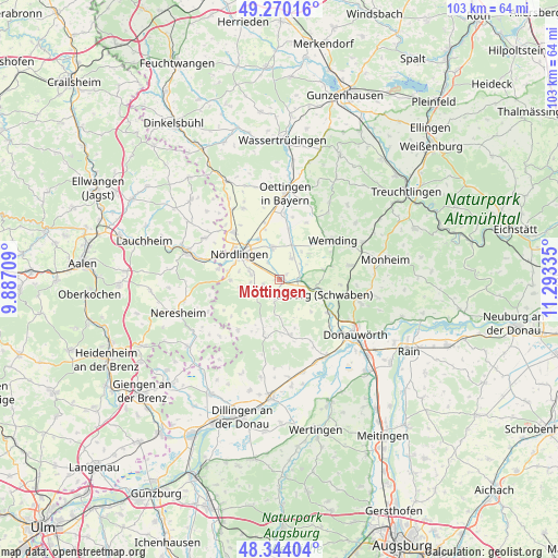
Möttingen GPS coordinates[2]
48° 48' 33.264" North, 10° 35' 24.792" East
| Map corner | latitude | longitude |
|---|---|---|
| Upper-left | 49.27016°, | 9.88709° |
| Center: | 48.80924°, | 10.59022° |
| Lower-right: | 48.34404°, | 11.29335° |
| Map W x H: | 103×103 km | = 64×64mi |
| max Lat: | 55.01917° ⇑85.2% North |
| Möttingen: | 48.80924° |
| min Lat: | ⇓14.8% South 47.40724° |
| min Long | Möttingen | max Long |
| 5.92978° | 10.59022° | 14.98853° |
| W 60.6%⇐ | ⇒39.4% E |
Elevation
Elevation of Möttingen is 416 m = 1365 ft, and this is 166.9 m = 548 ft above average elevation for this country.
| Max E: |
1256 m = 4121 ft | 22.4% |
| Möttingen | 416 m 1365 ft | |
| Avg. | 249.1 m = 817 ft | |
Min E: |
-5 m = -16 ft | 77.6% |
See also: Germany elevation on elevation.city.
Geographical zone
Möttingen is located in North temperate zone (between Tropic of Cancer and the Arctic Circle). Distance of this North polar circle is 1974.1 km =1226.6 mi to North.| Distance of | km | miles | from Möttingen |
|---|---|---|---|
| North Pole | 4580 | 2845.9 | to North |
| Arctic Circle | 1974.1 | 1226.6 | to North |
| Tropic Cancer | 2821.2 | 1753 | to South |
| Equator | 5427.1 | 3372.2 | to South |


Nearby cities:
15 places around Möttingen: (largest is in red/bold)
• Alerheim
4.9 km =3 mi,  23°
23°
• Amerdingen
12 km =7.5 mi,  219°
219°
• Bissingen
10.5 km =6.5 mi,  168°
168°
• Deiningen
6.6 km =4.1 mi,  344°
344°
• Ederheim
9.1 km =5.7 mi,  269°
269°
• Forheim
11.3 km =7 mi,  245°
245°
• Harburg
7.7 km =4.8 mi,  109°
109°
• Hohenaltheim
4.9 km =3 mi,  235°
235°
• Huisheim
8.5 km =5.3 mi,  77°
77°
• Munningen
12 km =7.5 mi,  3°
3°
• Mönchsdeggingen
3.8 km =2.4 mi,  190°
190°
• Nördlingen
8.8 km =5.5 mi,  302°
302°
• Reimlingen
5.4 km =3.4 mi,  278°
278°
• Wallerstein
12.1 km =7.5 mi,  316°
316°
• Wechingen
9.4 km =5.8 mi,  10°
10°
Sources, notices
• [Note1] Compared only with cities in Germany existing in our database
• [Src1] Map data: © OpenStreetMap contributors (CC-BY-SA)
• [Src2] Other city data from geonames.org with taken over terms of usage.
• [Src3] Geographical zone / Annual Mean Temperature by Robert A. Rohde @ Wikipedia
