Harburg geodata
Harburg (Bavaria) is a populated place; located in Germany in Europe/Berlin (GMT+2) time zone. With population of 5,694 people, there are 2568 cities with bigger population in this country. Compared to other cities in Germany, 85.5% of cities are located further ↑North; 62.3% of cities are located further ←West and 76.8% of cities have lower elevation than Harburg. Note1
Administrative division(s):
- Level 1: Bavaria
- Level 2: Swabia
- Level 3: Landkreis Donau-Ries
- Level 4: Harburg (Schwaben)


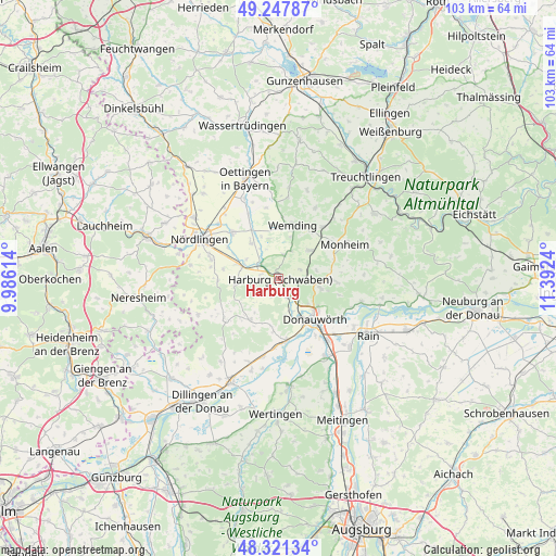
Harburg GPS coordinates[2]
48° 47' 12.264" North, 10° 41' 21.372" East
| Map corner | latitude | longitude |
|---|---|---|
| Upper-left | 49.24787°, | 9.98614° |
| Center: | 48.78674°, | 10.68927° |
| Lower-right: | 48.32134°, | 11.3924° |
| Map W x H: | 103×103 km | = 64×64mi |
| max Lat: | 55.01917° ⇑85.5% North |
| Harburg: | 48.78674° |
| min Lat: | ⇓14.5% South 47.40724° |
| min Long | Harburg | max Long |
| 5.92978° | 10.68927° | 14.98853° |
| W 62.3%⇐ | ⇒37.7% E |
Elevation
Elevation of Harburg is 411 m = 1348 ft, and this is 161.9 m = 531 ft above average elevation for this country.
| Max E: |
1256 m = 4121 ft | 23.2% |
| Harburg | 411 m 1348 ft | |
| Avg. | 249.1 m = 817 ft | |
Min E: |
-5 m = -16 ft | 76.8% |
See also: Germany elevation on elevation.city.
Geographical zone
Harburg is located in North temperate zone (between Tropic of Cancer and the Arctic Circle). Distance of this North polar circle is 1976.6 km =1228.2 mi to North.| Distance of | km | miles | from Harburg |
|---|---|---|---|
| North Pole | 4582.5 | 2847.4 | to North |
| Arctic Circle | 1976.6 | 1228.2 | to North |
| Tropic Cancer | 2818.7 | 1751.5 | to South |
| Equator | 5424.6 | 3370.7 | to South |


Nearby cities:
15 places around Harburg: (largest is in red/bold)
• Alerheim
8.8 km =5.5 mi,  322°
322°
• Bissingen
9.4 km =5.8 mi,  214°
214°
• Buchdorf
10.6 km =6.6 mi,  92°
92°
• Deiningen
12.6 km =7.8 mi,  314°
314°
• Donauwörth
10.1 km =6.3 mi,  139°
139°
• Fünfstetten
7.5 km =4.7 mi,  47°
47°
• Hohenaltheim
11.3 km =7 mi,  268°
268°
• Huisheim
4.4 km =2.7 mi,  13°
13°
• Kaisheim
8.1 km =5 mi,  105°
105°
• Mönchsdeggingen
8.1 km =5 mi,  261°
261°
• Möttingen
7.7 km =4.8 mi,  289°
289°
• Otting
12.5 km =7.8 mi,  40°
40°
• Tapfheim
12.6 km =7.8 mi,  181°
181°
• Wechingen
13 km =8.1 mi,  334°
334°
• Wemding
10.1 km =6.3 mi, 14°
Sources, notices
• [Note1] Compared only with cities in Germany existing in our database
• [Src1] Map data: © OpenStreetMap contributors (CC-BY-SA)
• [Src2] Other city data from geonames.org with taken over terms of usage.
• [Src3] Geographical zone / Annual Mean Temperature by Robert A. Rohde @ Wikipedia
