Ederheim geodata
Ederheim (Bavaria) is a seat of a fourth-order administrative division; located in Germany in Europe/Berlin (GMT+2) time zone. With population of 1,146 people, there are 6710 cities with bigger population in this country. Compared to other cities in Germany, 85.2% of cities are located further ↑North; 58.3% of cities are located further ←West and 85.3% of cities have lower elevation than Ederheim. Note1
Administrative division(s):
- Level 1: Bavaria
- Level 2: Swabia
- Level 3: Landkreis Donau-Ries
- Level 4: Ederheim


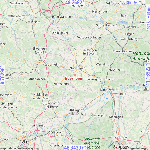
Ederheim GPS coordinates[2]
48° 48' 29.772" North, 10° 27' 57.924" East
| Map corner | latitude | longitude |
|---|---|---|
| Upper-left | 49.2692°, | 9.76296° |
| Center: | 48.80827°, | 10.46609° |
| Lower-right: | 48.34307°, | 11.16922° |
| Map W x H: | 103×103 km | = 64×64mi |
| max Lat: | 55.01917° ⇑85.2% North |
| Ederheim: | 48.80827° |
| min Lat: | ⇓14.8% South 47.40724° |
| min Long | Ederheim | max Long |
| 5.92978° | 10.46609° | 14.98853° |
| W 58.3%⇐ | ⇒41.7% E |
Elevation
Elevation of Ederheim is 472 m = 1549 ft, and this is 222.9 m = 731 ft above average elevation for this country.
| Max E: |
1256 m = 4121 ft | 14.7% |
| Ederheim | 472 m 1549 ft | |
| Avg. | 249.1 m = 817 ft | |
Min E: |
-5 m = -16 ft | 85.3% |
See also: Germany elevation on elevation.city.
Geographical zone
Ederheim is located in North temperate zone (between Tropic of Cancer and the Arctic Circle). Distance of this North polar circle is 1974.2 km =1226.7 mi to North.| Distance of | km | miles | from Ederheim |
|---|---|---|---|
| North Pole | 4580.1 | 2845.9 | to North |
| Arctic Circle | 1974.2 | 1226.7 | to North |
| Tropic Cancer | 2821.1 | 1752.9 | to South |
| Equator | 5427 | 3372.2 | to South |


Nearby cities:
15 places around Ederheim: (largest is in red/bold)
• Alerheim
12 km =7.5 mi,  67°
67°
• Amerdingen
9.3 km =5.8 mi,  171°
171°
• Bopfingen
9.9 km =6.2 mi,  304°
304°
• Deiningen
9.8 km =6.1 mi,  48°
48°
• Forheim
4.8 km =3 mi,  194°
194°
• Hohenaltheim
5.7 km =3.5 mi,  118°
118°
• Kirchheim am Ries
9.2 km =5.7 mi,  328°
328°
• Maihingen
13.5 km =8.4 mi,  10°
10°
• Marktoffingen
13.1 km =8.1 mi,  1°
1°
• Mönchsdeggingen
9.1 km =5.7 mi,  113°
113°
• Möttingen
9.1 km =5.7 mi,  89°
89°
• Neresheim
11.6 km =7.2 mi,  239°
239°
• Nördlingen
5.1 km =3.2 mi,  19°
19°
• Reimlingen
3.8 km =2.4 mi,  75°
75°
• Wallerstein
8.8 km =5.5 mi, 4°
Sources, notices
• [Note1] Compared only with cities in Germany existing in our database
• [Src1] Map data: © OpenStreetMap contributors (CC-BY-SA)
• [Src2] Other city data from geonames.org with taken over terms of usage.
• [Src3] Geographical zone / Annual Mean Temperature by Robert A. Rohde @ Wikipedia
