Milda geodata
Milda (Thuringia) is a seat of a fourth-order administrative division; located in Germany in Europe/Berlin (GMT+2) time zone. With population of 832 people, there are 7766 cities with bigger population in this country. Compared to other cities in Germany, 55.3% of cities are located further ↓South; 73.7% of cities are located further ←West and 75.6% of cities have lower elevation than Milda. Note1


Milda GPS coordinates[2]
50° 51' 21.312" North, 11° 27' 48.78" East
| Map corner | latitude | longitude |
|---|---|---|
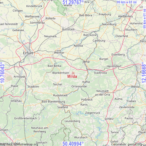
| Upper-left | 51.29767°, | 10.76043° |
| Center: | 50.85592°, | 11.46355° |
| Lower-right: | 50.40994°, | 12.16668° |
| Map W x H: | 98.7×98.7 km | = 61.3×61.3mi |
| max Lat: | 55.01917° ⇑44.7% North |
| Milda: | 50.85592° |
| min Lat: | ⇓55.3% South 47.40724° |
| min Long | Milda | max Long |
| 5.92978° | 11.46355° | 14.98853° |
| W 73.7%⇐ | ⇒26.3% E |
Elevation
Elevation of Milda is 402 m = 1319 ft, and this is 152.9 m = 502 ft above average elevation for this country.
| Max E: |
1256 m = 4121 ft | 24.4% |
| Milda | 402 m 1319 ft | |
| Avg. | 249.1 m = 817 ft | |
Min E: |
-5 m = -16 ft | 75.6% |
See also: Germany elevation on elevation.city.
Geographical zone
Milda is located in North temperate zone (between Tropic of Cancer and the Arctic Circle). Distance of this North polar circle is 1746.5 km =1085.2 mi to North.| Distance of | km | miles | from Milda |
|---|---|---|---|
| North Pole | 4352.4 | 2704.5 | to North |
| Arctic Circle | 1746.5 | 1085.2 | to North |
| Tropic Cancer | 3048.7 | 1894.4 | to South |
| Equator | 5654.6 | 3513.6 | to South |


Nearby cities:
15 places around Milda: (largest is in red/bold)
• Altenberga
5.5 km =3.4 mi,  117°
117°
• Bibra
8.2 km =5.1 mi,  134°
134°
• Blankenhain
8.4 km =5.2 mi,  273°
273°
• Bucha
4.8 km =3 mi,  50°
50°
• Döbritschen
7.1 km =4.4 mi,  7°
7°
• Eichenberg
7.9 km =4.9 mi,  141°
141°
• Großschwabhausen
8.7 km =5.4 mi, 9°
• Gumperda
6.7 km =4.2 mi, 140°
• Kiliansroda
9.2 km =5.7 mi,  315°
315°
• Kleinschwabhausen
8.4 km =5.2 mi,  358°
358°
• Lehnstedt
8.9 km =5.5 mi,  346°
346°
• Magdala
5.8 km =3.6 mi, 349°
• Mechelroda
8.6 km =5.3 mi, 315°
• Reinstädt
5.2 km =3.2 mi,  171°
171°
• Rothenstein
9.6 km =6 mi,  93°
93°
Sources, notices
• [Note1] Compared only with cities in Germany existing in our database
• [Src1] Map data: © OpenStreetMap contributors (CC-BY-SA)
• [Src2] Other city data from geonames.org with taken over terms of usage.
• [Src3] Geographical zone / Annual Mean Temperature by Robert A. Rohde @ Wikipedia
