Reinstädt geodata
Reinstädt (Thuringia) is a seat of a fourth-order administrative division; located in Germany in Europe/Berlin (GMT+2) time zone. With population of 579 people, there are 8928 cities with bigger population in this country. Compared to other cities in Germany, 54.4% of cities are located further ↓South; 73.9% of cities are located further ←West and 54.2% of cities have lower elevation than Reinstädt. Note1


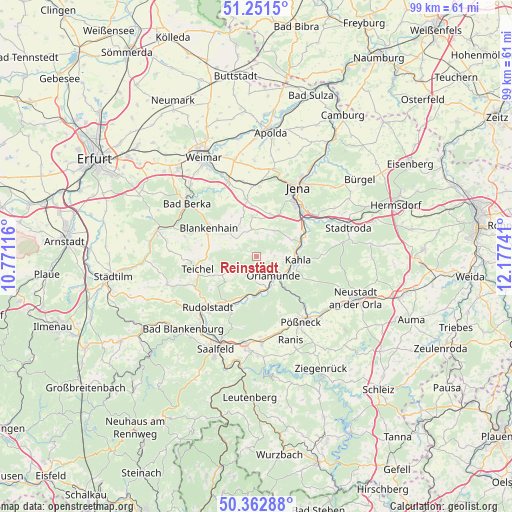
Reinstädt GPS coordinates[2]
50° 48' 33.48" North, 11° 28' 27.408" East
| Map corner | latitude | longitude |
|---|---|---|
| Upper-left | 51.2515°, | 10.77116° |
| Center: | 50.8093°, | 11.47428° |
| Lower-right: | 50.36288°, | 12.17741° |
| Map W x H: | 98.8×98.8 km | = 61.4×61.4mi |
| max Lat: | 55.01917° ⇑45.6% North |
| Reinstädt: | 50.8093° |
| min Lat: | ⇓54.4% South 47.40724° |
| min Long | Reinstädt | max Long |
| 5.92978° | 11.47428° | 14.98853° |
| W 73.9%⇐ | ⇒26.1% E |
Elevation
Elevation of Reinstädt is 253 m = 830 ft, and this is 3.9 m = 13 ft above average elevation for this country.
| Max E: |
1256 m = 4121 ft | 45.8% |
| Reinstädt | 253 m 830 ft | |
| Avg. | 249.1 m = 817 ft | |
Min E: |
-5 m = -16 ft | 54.2% |
See also: Germany elevation on elevation.city.
Geographical zone
Reinstädt is located in North temperate zone (between Tropic of Cancer and the Arctic Circle). Distance of this North polar circle is 1751.7 km =1088.5 mi to North.| Distance of | km | miles | from Reinstädt |
|---|---|---|---|
| North Pole | 4357.6 | 2707.7 | to North |
| Arctic Circle | 1751.7 | 1088.5 | to North |
| Tropic Cancer | 3043.5 | 1891.1 | to South |
| Equator | 5649.5 | 3510.4 | to South |


Nearby cities:
15 places around Reinstädt: (largest is in red/bold)
• Altenberga
4.9 km =3 mi,  57°
57°
• Bibra
5.1 km =3.2 mi,  96°
96°
• Bucha
8.8 km =5.5 mi,  19°
19°
• Eichenberg
4.3 km =2.7 mi, 103°
• Freienorla
7.1 km =4.4 mi,  131°
131°
• Großeutersdorf
7.1 km =4.4 mi,  113°
113°
• Großkochberg
9.2 km =5.7 mi,  245°
245°
• Großpürschütz
8.9 km =5.5 mi,  84°
84°
• Gumperda
3.5 km =2.2 mi,  89°
89°
• Kahla
7.8 km =4.8 mi, 92°
• Kleineutersdorf
8.2 km =5.1 mi, 110°
• Milda
5.2 km =3.2 mi,  351°
351°
• Orlamünde
5 km =3.1 mi,  140°
140°
• Rückersdorf
8 km =5 mi,  179°
179°
• Schöps
9.2 km =5.7 mi,  73°
73°
Sources, notices
• [Note1] Compared only with cities in Germany existing in our database
• [Src1] Map data: © OpenStreetMap contributors (CC-BY-SA)
• [Src2] Other city data from geonames.org with taken over terms of usage.
• [Src3] Geographical zone / Annual Mean Temperature by Robert A. Rohde @ Wikipedia
