Kleinschwabhausen geodata
Kleinschwabhausen (Thuringia) is a seat of a fourth-order administrative division; located in Germany in Europe/Berlin (GMT+2) time zone. With population of 264 people, there are 10190 cities with bigger population in this country. Compared to other cities in Germany, 56.8% of cities are located further ↓South; 73.6% of cities are located further ←West and 64.3% of cities have lower elevation than Kleinschwabhausen. Note1


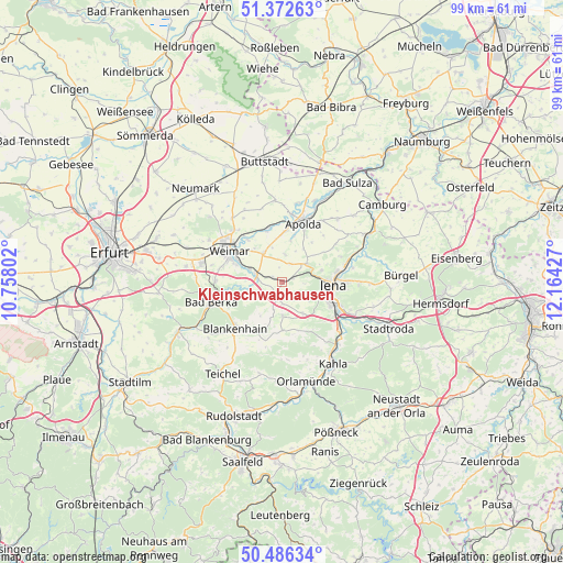
Kleinschwabhausen GPS coordinates[2]
50° 55' 53.76" North, 11° 27' 40.104" East
| Map corner | latitude | longitude |
|---|---|---|
| Upper-left | 51.37263°, | 10.75802° |
| Center: | 50.9316°, | 11.46114° |
| Lower-right: | 50.48634°, | 12.16427° |
| Map W x H: | 98.5×98.5 km | = 61.2×61.2mi |
| max Lat: | 55.01917° ⇑43.2% North |
| Kleinschwabhausen: | 50.9316° |
| min Lat: | ⇓56.8% South 47.40724° |
| min Long | Kleinschwabhaus | max Long |
| 5.92978° | 11.46114° | 14.98853° |
| W 73.6%⇐ | ⇒26.4% E |
Elevation
Elevation of Kleinschwabhausen is 317 m = 1040 ft, and this is 67.9 m = 223 ft above average elevation for this country.
| Max E: |
1256 m = 4121 ft | 35.7% |
| Kleinschwabhausen | 317 m 1040 ft | |
| Avg. | 249.1 m = 817 ft | |
Min E: |
-5 m = -16 ft | 64.3% |
See also: Germany elevation on elevation.city.
Geographical zone
Kleinschwabhausen is located in North temperate zone (between Tropic of Cancer and the Arctic Circle). Distance of this North polar circle is 1738.1 km =1080 mi to North.| Distance of | km | miles | from Kleinschwabhausen |
|---|---|---|---|
| North Pole | 4344 | 2699.2 | to North |
| Arctic Circle | 1738.1 | 1080 | to North |
| Tropic Cancer | 3057.1 | 1899.6 | to South |
| Equator | 5663.1 | 3518.9 | to South |


Nearby cities:
15 places around Kleinschwabhausen: (largest is in red/bold)
• Bucha
6.6 km =4.1 mi,  144°
144°
• Döbritschen
1.7 km =1.1 mi, 142°
• Frankendorf
4 km =2.5 mi,  348°
348°
• Großschwabhausen
1.6 km =1 mi,  82°
82°
• Hammerstedt
2.6 km =1.6 mi, 349°
• Kapellendorf
4.8 km =3 mi,  6°
6°
• Kiliansroda
6.6 km =4.1 mi,  253°
253°
• Lehnstedt
2 km =1.2 mi,  275°
275°
• Magdala
2.9 km =1.8 mi,  198°
198°
• Mechelroda
6.2 km =3.9 mi, 248°
• Mellingen
4.7 km =2.9 mi, 283°
• Milda
8.4 km =5.2 mi,  178°
178°
• Oettern
7.3 km =4.5 mi,  262°
262°
• Umpferstedt
6.5 km =4 mi,  331°
331°
• Wiegendorf
6.1 km =3.8 mi,  341°
341°
Sources, notices
• [Note1] Compared only with cities in Germany existing in our database
• [Src1] Map data: © OpenStreetMap contributors (CC-BY-SA)
• [Src2] Other city data from geonames.org with taken over terms of usage.
• [Src3] Geographical zone / Annual Mean Temperature by Robert A. Rohde @ Wikipedia
