Gessertshausen geodata
Gessertshausen (Bavaria) is a seat of a fourth-order administrative division; located in Germany in Europe/Berlin (GMT+2) time zone. With population of 4,424 people, there are 3081 cities with bigger population in this country. Compared to other cities in Germany, 90.9% of cities are located further ↑North; 63% of cities are located further ←West and 86.6% of cities have lower elevation than Gessertshausen. Note1
Administrative division(s):
- Level 1: Bavaria
- Level 2: Swabia
- Level 3: Landkreis Augsburg
- Level 4: Gessertshausen


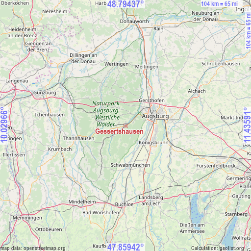
Gessertshausen GPS coordinates[2]
48° 19' 44.544" North, 10° 43' 58.008" East
| Map corner | latitude | longitude |
|---|---|---|
| Upper-left | 48.79437°, | 10.02966° |
| Center: | 48.32904°, | 10.73278° |
| Lower-right: | 47.85942°, | 11.43591° |
| Map W x H: | 104×104 km | = 64.6×64.6mi |
| max Lat: | 55.01917° ⇑90.9% North |
| Gessertshausen: | 48.32904° |
| min Lat: | ⇓9.1% South 47.40724° |
| min Long | Gessertshausen | max Long |
| 5.92978° | 10.73278° | 14.98853° |
| W 63%⇐ | ⇒37% E |
Elevation
Elevation of Gessertshausen is 482 m = 1581 ft, and this is 232.9 m = 764 ft above average elevation for this country.
| Max E: |
1256 m = 4121 ft | 13.4% |
| Gessertshausen | 482 m 1581 ft | |
| Avg. | 249.1 m = 817 ft | |
Min E: |
-5 m = -16 ft | 86.6% |
See also: Germany elevation on elevation.city.
Geographical zone
Gessertshausen is located in North temperate zone (between Tropic of Cancer and the Arctic Circle). Distance of this North polar circle is 2027.5 km =1259.8 mi to North.| Distance of | km | miles | from Gessertshausen |
|---|---|---|---|
| North Pole | 4633.4 | 2879.1 | to North |
| Arctic Circle | 2027.5 | 1259.8 | to North |
| Tropic Cancer | 2767.8 | 1719.8 | to South |
| Equator | 5373.7 | 3339.1 | to South |


Nearby cities:
15 places around Gessertshausen: (largest is in red/bold)
• Adelsried
10.7 km =6.6 mi,  354°
354°
• Aystetten
9.1 km =5.7 mi,  21°
21°
• Bobingen
9.9 km =6.2 mi,  130°
130°
• Diedorf
4.5 km =2.8 mi,  53°
53°
• Dinkelscherben
10.8 km =6.7 mi,  281°
281°
• Fischach
7.1 km =4.4 mi,  232°
232°
• Großaitingen
11.8 km =7.3 mi,  162°
162°
• Horgau
8.2 km =5.1 mi,  333°
333°
• Kutzenhausen
3.2 km =2 mi,  297°
297°
• Langenneufnach
12 km =7.5 mi, 234°
• Mickhausen
11.9 km =7.4 mi,  215°
215°
• Rommelsried
4.7 km =2.9 mi,  341°
341°
• Stadtbergen
9.4 km =5.8 mi,  63°
63°
• Ustersbach
6.3 km =3.9 mi,  257°
257°
• Wehringen
10.1 km =6.3 mi,  150°
150°
Sources, notices
• [Note1] Compared only with cities in Germany existing in our database
• [Src1] Map data: © OpenStreetMap contributors (CC-BY-SA)
• [Src2] Other city data from geonames.org with taken over terms of usage.
• [Src3] Geographical zone / Annual Mean Temperature by Robert A. Rohde @ Wikipedia
