Meezen geodata
Meezen (Schleswig-Holstein) is a seat of a fourth-order administrative division; located in Germany in Europe/Berlin (GMT+2) time zone. With population of 389 people, there are 9725 cities with bigger population in this country. Compared to other cities in Germany, 93.3% of cities are located further ↓South; 54.4% of cities are located further →East and 80.6% of cities have higher elevation than Meezen. Note1
Administrative division(s):
- Level 1: Schleswig-Holstein
- Level 3: Kreis Rendsburg-Eckernförde
- Level 4: Meezen


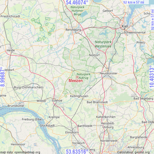
Meezen GPS coordinates[2]
54° 3' 0" North, 9° 42' 0" East
| Map corner | latitude | longitude |
|---|---|---|
| Upper-left | 54.46074°, | 8.99687° |
| Center: | 54.05°, | 9.7° |
| Lower-right: | 53.63516°, | 10.40313° |
| Map W x H: | 91.8×91.8 km | = 57×57mi |
| max Lat: | 55.01917° ⇑6.7% North |
| Meezen: | 54.05° |
| min Lat: | ⇓93.3% South 47.40724° |
| min Long | Meezen | max Long |
| 5.92978° | 9.7° | 14.98853° |
| W 45.6%⇐ | ⇒54.4% E |
Elevation
Elevation of Meezen is 45 m = 148 ft, and this is 204.1 m = 670 ft below average elevation for this country.
| Max E: |
1256 m = 4121 ft | 80.6% |
| Avg. | 249.1 m = 817 ft | |
| Meezen | 45 m = 148 ft | |
Min E: |
-5 m = -16 ft | 19.4% |
See also: Germany elevation on elevation.city.
Geographical zone
Meezen is located in North temperate zone (between Tropic of Cancer and the Arctic Circle). Distance of this North polar circle is 1391.4 km =864.6 mi to North.| Distance of | km | miles | from Meezen |
|---|---|---|---|
| North Pole | 3997.3 | 2483.8 | to North |
| Arctic Circle | 1391.4 | 864.6 | to North |
| Tropic Cancer | 3403.9 | 2115.1 | to South |
| Equator | 6009.8 | 3734.3 | to South |


Nearby cities:
15 places around Meezen: (largest is in red/bold)
• Aukrug
6.6 km =4.1 mi,  55°
55°
• Fitzbek
7.1 km =4.4 mi,  141°
141°
• Grauel
2.9 km =1.8 mi,  310°
310°
• Hennstedt
2.1 km =1.3 mi,  149°
149°
• Hohenwestedt
5.3 km =3.3 mi,  324°
324°
• Jahrsdorf
4.7 km =2.9 mi,  293°
293°
• Lockstedt
5.7 km =3.5 mi,  191°
191°
• Oeschebüttel
6.9 km =4.3 mi,  168°
168°
• Peissen
6.6 km =4.1 mi,  246°
246°
• Poyenberg
1.9 km =1.2 mi,  180°
180°
• Rade
6.1 km =3.8 mi, 153°
• Sarlhusen
6.8 km =4.2 mi,  116°
116°
• Silzen
5.7 km =3.5 mi, 251°
• Tappendorf
6 km =3.7 mi,  356°
356°
• Willenscharen
7.5 km =4.7 mi, 119°
Sources, notices
• [Note1] Compared only with cities in Germany existing in our database
• [Src1] Map data: © OpenStreetMap contributors (CC-BY-SA)
• [Src2] Other city data from geonames.org with taken over terms of usage.
• [Src3] Geographical zone / Annual Mean Temperature by Robert A. Rohde @ Wikipedia
