Medard geodata
Medard (Rheinland-Pfalz) is a seat of a fourth-order administrative division; located in Germany in Europe/Berlin (GMT+2) time zone. With population of 526 people, there are 9221 cities with bigger population in this country. Compared to other cities in Germany, 72.2% of cities are located further ↑North; 84.8% of cities are located further →East and 59.4% of cities have higher elevation than Medard. Note1


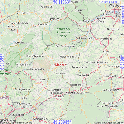
Medard GPS coordinates[2]
49° 40' 0.012" North, 7° 37' 0.012" East
| Map corner | latitude | longitude |
|---|---|---|
| Upper-left | 50.11963°, | 6.91355° |
| Center: | 49.66667°, | 7.61667° |
| Lower-right: | 49.20945°, | 8.3198° |
| Map W x H: | 101.2×101.2 km | = 62.9×62.9mi |
| max Lat: | 55.01917° ⇑72.2% North |
| Medard: | 49.66667° |
| min Lat: | ⇓27.8% South 47.40724° |
| min Long | Medard | max Long |
| 5.92978° | 7.61667° | 14.98853° |
| W 15.2%⇐ | ⇒84.8% E |
Elevation
Elevation of Medard is 157 m = 515 ft, and this is 92.1 m = 302 ft below average elevation for this country.
| Max E: |
1256 m = 4121 ft | 59.4% |
| Avg. | 249.1 m = 817 ft | |
| Medard | 157 m = 515 ft | |
Min E: |
-5 m = -16 ft | 40.6% |
See also: Germany elevation on elevation.city.
Geographical zone
Medard is located in North temperate zone (between Tropic of Cancer and the Arctic Circle). Distance of this North polar circle is 1878.8 km =1167.4 mi to North.| Distance of | km | miles | from Medard |
|---|---|---|---|
| North Pole | 4484.6 | 2786.6 | to North |
| Arctic Circle | 1878.8 | 1167.4 | to North |
| Tropic Cancer | 2916.5 | 1812.2 | to South |
| Equator | 5522.4 | 3431.5 | to South |


Nearby cities:
15 places around Medard: (largest is in red/bold)
• Adenbach
2.4 km =1.5 mi,  90°
90°
• Becherbach
5.1 km =3.2 mi,  111°
111°
• Breitenheim
3.9 km =2.4 mi,  17°
17°
• Cronenberg
1.9 km =1.2 mi,  180°
180°
• Ginsweiler
3 km =1.9 mi,  127°
127°
• Grumbach
4 km =2.5 mi,  242°
242°
• Hausweiler
4 km =2.5 mi, 242°
• Heinzenhausen
3.9 km =2.4 mi,  197°
197°
• Kappeln
4 km =2.5 mi,  297°
297°
• Lauterecken
2.5 km =1.6 mi,  222°
222°
• Lohnweiler
3.9 km =2.4 mi, 197°
• Löllbach
3 km =1.9 mi,  307°
307°
• Odenbach
3 km =1.9 mi,  52°
52°
• Reiffelbach
5.1 km =3.2 mi,  68°
68°
• Reipoltskirchen
5.2 km =3.2 mi,  135°
135°
Sources, notices
• [Note1] Compared only with cities in Germany existing in our database
• [Src1] Map data: © OpenStreetMap contributors (CC-BY-SA)
• [Src2] Other city data from geonames.org with taken over terms of usage.
• [Src3] Geographical zone / Annual Mean Temperature by Robert A. Rohde @ Wikipedia
