Meckenbach geodata
Meckenbach (Rheinland-Pfalz) is a seat of a fourth-order administrative division; located in Germany in Europe/Berlin (GMT+2) time zone. With population of 422 people, there are 9628 cities with bigger population in this country. Compared to other cities in Germany, 69.4% of cities are located further ↑North; 87.1% of cities are located further →East and 64.9% of cities have lower elevation than Meckenbach. Note1
Administrative division(s):
- Level 1: Rheinland-Pfalz
- Level 3: Landkreis Bad Kreuznach
- Level 4: Meckenbach


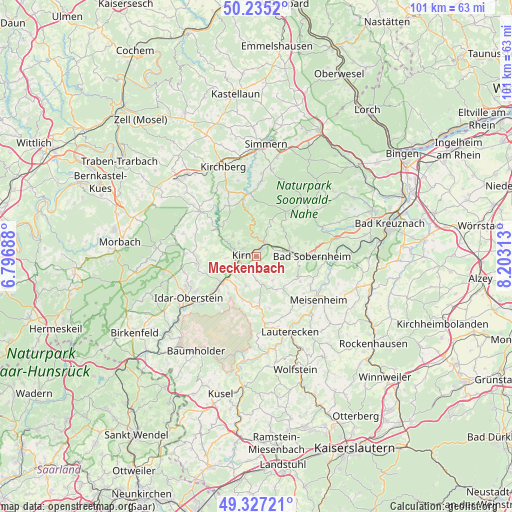
Meckenbach GPS coordinates[2]
49° 46' 59.988" North, 7° 30' 0" East
| Map corner | latitude | longitude |
|---|---|---|
| Upper-left | 50.2352°, | 6.79688° |
| Center: | 49.78333°, | 7.5° |
| Lower-right: | 49.32721°, | 8.20313° |
| Map W x H: | 101×101 km | = 62.8×62.8mi |
| max Lat: | 55.01917° ⇑69.4% North |
| Meckenbach: | 49.78333° |
| min Lat: | ⇓30.6% South 47.40724° |
| min Long | Meckenbach | max Long |
| 5.92978° | 7.5° | 14.98853° |
| W 12.9%⇐ | ⇒87.1% E |
Elevation
Elevation of Meckenbach is 320 m = 1050 ft, and this is 70.9 m = 233 ft above average elevation for this country.
| Max E: |
1256 m = 4121 ft | 35.1% |
| Meckenbach | 320 m 1050 ft | |
| Avg. | 249.1 m = 817 ft | |
Min E: |
-5 m = -16 ft | 64.9% |
See also: Germany elevation on elevation.city.
Geographical zone
Meckenbach is located in North temperate zone (between Tropic of Cancer and the Arctic Circle). Distance of this North polar circle is 1865.8 km =1159.4 mi to North.| Distance of | km | miles | from Meckenbach |
|---|---|---|---|
| North Pole | 4471.7 | 2778.6 | to North |
| Arctic Circle | 1865.8 | 1159.4 | to North |
| Tropic Cancer | 2929.5 | 1820.3 | to South |
| Equator | 5535.4 | 3439.5 | to South |


Nearby cities:
15 places around Meckenbach: (largest is in red/bold)
• Bergen
6 km =3.7 mi,  270°
270°
• Brauweiler
3.7 km =2.3 mi,  0°
0°
• Bärenbach
5.2 km =3.2 mi,  224°
224°
• Hahnenbach
6.5 km =4 mi,  296°
296°
• Heinzenberg
3.9 km =2.4 mi,  342°
342°
• Hennweiler
6.1 km =3.8 mi,  307°
307°
• Hochstetten-Dhaun
1.9 km =1.2 mi, 0°
• Horbach
3.9 km =2.4 mi,  17°
17°
• Kirn
3.1 km =1.9 mi,  281°
281°
• Kirschroth
5.1 km =3.2 mi,  111°
111°
• Limbach
6.6 km =4.1 mi,  147°
147°
• Martinstein
3.8 km =2.4 mi,  55°
55°
• Merxheim
4.4 km =2.7 mi,  76°
76°
• Schmidthachenbach
6.1 km =3.8 mi,  203°
203°
• Simmertal
3.4 km =2.1 mi,  29°
29°
Sources, notices
• [Note1] Compared only with cities in Germany existing in our database
• [Src1] Map data: © OpenStreetMap contributors (CC-BY-SA)
• [Src2] Other city data from geonames.org with taken over terms of usage.
• [Src3] Geographical zone / Annual Mean Temperature by Robert A. Rohde @ Wikipedia
