Marienhafe geodata
Marienhafe (Lower Saxony) is a populated place; located in Germany in Europe/Berlin (GMT+2) time zone. With population of 2,032 people, there are 5019 cities with bigger population in this country. Compared to other cities in Germany, 85.8% of cities are located further ↓South; 90.4% of cities are located further →East and 96.6% of cities have higher elevation than Marienhafe. Note1
Administrative division(s):
- Level 1: Lower Saxony
- Level 3: Landkreis Aurich
- Level 4: Marienhafe, Flecken


Marienhafe GPS coordinates[2]
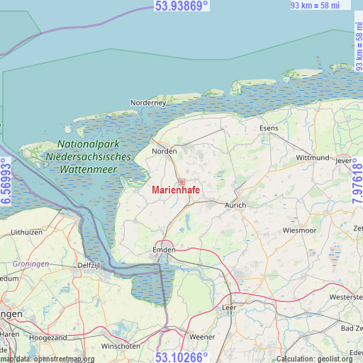
53° 31' 21.864" North, 7° 16' 23.016" East
| Map corner | latitude | longitude |
|---|---|---|
| Upper-left | 53.93869°, | 6.56993° |
| Center: | 53.52274°, | 7.27306° |
| Lower-right: | 53.10266°, | 7.97618° |
| Map W x H: | 93×93 km | = 57.8×57.8mi |
| max Lat: | 55.01917° ⇑14.2% North |
| Marienhafe: | 53.52274° |
| min Lat: | ⇓85.8% South 47.40724° |
| min Long | Marienhafe | max Long |
| 5.92978° | 7.27306° | 14.98853° |
| W 9.6%⇐ | ⇒90.4% E |
Elevation
Elevation of Marienhafe is 5 m = 16 ft, and this is 244.1 m = 801 ft below average elevation for this country.
| Max E: |
1256 m = 4121 ft | 96.6% |
| Avg. | 249.1 m = 817 ft | |
| Marienhafe | 5 m = 16 ft | |
Min E: |
-5 m = -16 ft | 3.4% |
See also: Germany elevation on elevation.city.
Geographical zone
Marienhafe is located in North temperate zone (between Tropic of Cancer and the Arctic Circle). Distance of this North polar circle is 1450 km =901 mi to North.| Distance of | km | miles | from Marienhafe |
|---|---|---|---|
| North Pole | 4055.9 | 2520.2 | to North |
| Arctic Circle | 1450 | 901 | to North |
| Tropic Cancer | 3345.3 | 2078.7 | to South |
| Equator | 5951.2 | 3697.9 | to South |


Nearby cities:
15 places around Marienhafe: (largest is in red/bold)
• Berumbur
9.1 km =5.7 mi,  18°
18°
• Eversmeer
11.4 km =7.1 mi,  68°
68°
• Hage
8.9 km =5.5 mi,  5°
5°
• Hagermarsch
14.3 km =8.9 mi, 7°
• Halbemond
5.1 km =3.2 mi, 13°
• Hinte
13.2 km =8.2 mi,  206°
206°
• Leezdorf
3.5 km =2.2 mi,  30°
30°
• Lütetsburg
8.7 km =5.4 mi,  349°
349°
• Nenndorf
12.5 km =7.8 mi,  57°
57°
• Norddeich
12.5 km =7.8 mi,  323°
323°
• Norden
9.2 km =5.7 mi,  331°
331°
• Osteel
2.7 km =1.7 mi, 332°
• Rechtsupweg
4.2 km =2.6 mi, 73°
• Upgant-Schott
1 km =0.6 mi,  134°
134°
• Wirdum
6.8 km =4.2 mi,  220°
220°
Sources, notices
• [Note1] Compared only with cities in Germany existing in our database
• [Src1] Map data: © OpenStreetMap contributors (CC-BY-SA)
• [Src2] Other city data from geonames.org with taken over terms of usage.
• [Src3] Geographical zone / Annual Mean Temperature by Robert A. Rohde @ Wikipedia
