Luckow geodata
Luckow (Mecklenburg-Vorpommern) is a populated place; located in Germany in Europe/Berlin (GMT+2) time zone. With population of 681 people, there are 8411 cities with bigger population in this country. Compared to other cities in Germany, 88.7% of cities are located further ↓South; 98.5% of cities are located further ←West and 96.6% of cities have higher elevation than Luckow. Note1
Administrative division(s):
- Level 1: Mecklenburg-Vorpommern
- Level 3: Vorpommern-Greifswald
- Level 4: Luckow


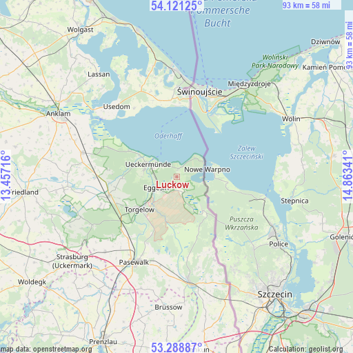
Luckow GPS coordinates[2]
53° 42' 25.632" North, 14° 9' 37.008" East
| Map corner | latitude | longitude |
|---|---|---|
| Upper-left | 54.12125°, | 13.45716° |
| Center: | 53.70712°, | 14.16028° |
| Lower-right: | 53.28887°, | 14.86341° |
| Map W x H: | 92.6×92.6 km | = 57.5×57.5mi |
| max Lat: | 55.01917° ⇑11.3% North |
| Luckow: | 53.70712° |
| min Lat: | ⇓88.7% South 47.40724° |
| min Long | Luckow | max Long |
| 5.92978° | 14.16028° | 14.98853° |
| W 98.5%⇐ | ⇒1.5% E |
Elevation
Elevation of Luckow is 5 m = 16 ft, and this is 244.1 m = 801 ft below average elevation for this country.
| Max E: |
1256 m = 4121 ft | 96.6% |
| Avg. | 249.1 m = 817 ft | |
| Luckow | 5 m = 16 ft | |
Min E: |
-5 m = -16 ft | 3.4% |
See also: Germany elevation on elevation.city.
Geographical zone
Luckow is located in North temperate zone (between Tropic of Cancer and the Arctic Circle). Distance of this North polar circle is 1429.5 km =888.2 mi to North.| Distance of | km | miles | from Luckow |
|---|---|---|---|
| North Pole | 4035.4 | 2507.5 | to North |
| Arctic Circle | 1429.5 | 888.2 | to North |
| Tropic Cancer | 3365.8 | 2091.4 | to South |
| Equator | 5971.7 | 3710.6 | to South |


Nearby cities:
15 places around Luckow: (largest is in red/bold)
• Ahlbeck
4.5 km =2.8 mi,  157°
157°
• Altwarp
7.9 km =4.9 mi,  61°
61°
• Dargen
21 km =13 mi,  342°
342°
• Eggesin
6.1 km =3.8 mi,  240°
240°
• Ferdinandshof
18.7 km =11.6 mi,  254°
254°
• Hammer
16.7 km =10.4 mi,  225°
225°
• Jatznick
20.3 km =12.6 mi, 225°
• Leopoldshagen
19.1 km =11.9 mi,  293°
293°
• Liepgarten
8.8 km =5.5 mi,  278°
278°
• Mönkebude
14.3 km =8.9 mi,  298°
298°
• Torgelow
12.6 km =7.8 mi, 230°
• Ueckermünde
8.3 km =5.2 mi, 294°
• Viereck
19.3 km =12 mi,  204°
204°
• Wilhelmsburg
21.2 km =13.2 mi, 250°
• Zirchow
20.4 km =12.7 mi,  356°
356°
Sources, notices
• [Note1] Compared only with cities in Germany existing in our database
• [Src1] Map data: © OpenStreetMap contributors (CC-BY-SA)
• [Src2] Other city data from geonames.org with taken over terms of usage.
• [Src3] Geographical zone / Annual Mean Temperature by Robert A. Rohde @ Wikipedia
