Dargen geodata
Dargen (Mecklenburg-Vorpommern) is a populated place; located in Germany in Europe/Berlin (GMT+2) time zone. With population of 555 people, there are 9057 cities with bigger population in this country. Compared to other cities in Germany, 91.1% of cities are located further ↓South; 98.2% of cities are located further ←West and 95.6% of cities have higher elevation than Dargen. Note1
Administrative division(s):
- Level 1: Mecklenburg-Vorpommern
- Level 3: Vorpommern-Greifswald
- Level 4: Dargen


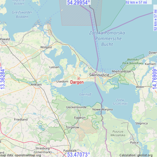
Dargen GPS coordinates[2]
53° 53' 13.884" North, 14° 3' 57.456" East
| Map corner | latitude | longitude |
|---|---|---|
| Upper-left | 54.29954°, | 13.36284° |
| Center: | 53.88719°, | 14.06596° |
| Lower-right: | 53.47073°, | 14.76909° |
| Map W x H: | 92.2×92.2 km | = 57.3×57.3mi |
| max Lat: | 55.01917° ⇑8.9% North |
| Dargen: | 53.88719° |
| min Lat: | ⇓91.1% South 47.40724° |
| min Long | Dargen | max Long |
| 5.92978° | 14.06596° | 14.98853° |
| W 98.2%⇐ | ⇒1.8% E |
Elevation
Elevation of Dargen is 7 m = 23 ft, and this is 242.1 m = 794 ft below average elevation for this country.
| Max E: |
1256 m = 4121 ft | 95.6% |
| Avg. | 249.1 m = 817 ft | |
| Dargen | 7 m = 23 ft | |
Min E: |
-5 m = -16 ft | 4.4% |
See also: Germany elevation on elevation.city.
Geographical zone
Dargen is located in North temperate zone (between Tropic of Cancer and the Arctic Circle). Distance of this North polar circle is 1409.5 km =875.8 mi to North.| Distance of | km | miles | from Dargen |
|---|---|---|---|
| North Pole | 4015.4 | 2495.1 | to North |
| Arctic Circle | 1409.5 | 875.8 | to North |
| Tropic Cancer | 3385.8 | 2103.8 | to South |
| Equator | 5991.7 | 3723.1 | to South |


Nearby cities:
15 places around Dargen: (largest is in red/bold)
• Benz
6 km =3.7 mi,  3°
3°
• Heringsdorf
9.6 km =6 mi,  43°
43°
• Korswandt
7.2 km =4.5 mi,  59°
59°
• Koserow
18.8 km =11.7 mi,  347°
347°
• Lassan
15.6 km =9.7 mi,  296°
296°
• Leopoldshagen
16.9 km =10.5 mi,  221°
221°
• Liepgarten
18.8 km =11.7 mi,  187°
187°
• Loddin
15.5 km =9.6 mi, 345°
• Mönkebude
14.7 km =9.1 mi,  205°
205°
• Rankwitz
11.2 km =7 mi,  305°
305°
• Seebad Bansin
10.6 km =6.6 mi,  27°
27°
• Seebad Heringsdorf
10 km =6.2 mi, 42°
• Ueckermünde
16.7 km =10.4 mi,  184°
184°
• Usedom
9.4 km =5.8 mi,  261°
261°
• Zirchow
4.8 km =3 mi,  85°
85°
Sources, notices
• [Note1] Compared only with cities in Germany existing in our database
• [Src1] Map data: © OpenStreetMap contributors (CC-BY-SA)
• [Src2] Other city data from geonames.org with taken over terms of usage.
• [Src3] Geographical zone / Annual Mean Temperature by Robert A. Rohde @ Wikipedia
