Lohne geodata
Lohne (Lower Saxony) is a populated place; located in Germany in Europe/Berlin (GMT+2) time zone. With population of 7,000 people, there are 2182 cities with bigger population in this country. Compared to other cities in Germany, 77.3% of cities are located further ↓South; 91% of cities are located further →East and 87.3% of cities have higher elevation than Lohne. Note1
Administrative division(s):
- Level 1: Lower Saxony
- Level 3: Landkreis Grafschaft Bentheim
- Level 4: Wietmarschen


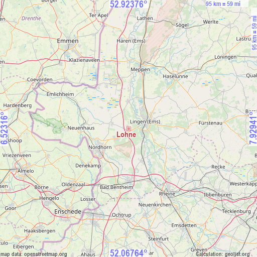
Lohne GPS coordinates[2]
52° 29' 52.008" North, 7° 13' 34.644" East
| Map corner | latitude | longitude |
|---|---|---|
| Upper-left | 52.92376°, | 6.52316° |
| Center: | 52.49778°, | 7.22629° |
| Lower-right: | 52.06764°, | 7.92941° |
| Map W x H: | 95.2×95.2 km | = 59.2×59.2mi |
| max Lat: | 55.01917° ⇑22.7% North |
| Lohne: | 52.49778° |
| min Lat: | ⇓77.3% South 47.40724° |
| min Long | Lohne | max Long |
| 5.92978° | 7.22629° | 14.98853° |
| W 9%⇐ | ⇒91% E |
Elevation
Elevation of Lohne is 29 m = 95 ft, and this is 220.1 m = 722 ft below average elevation for this country.
| Max E: |
1256 m = 4121 ft | 87.3% |
| Avg. | 249.1 m = 817 ft | |
| Lohne | 29 m = 95 ft | |
Min E: |
-5 m = -16 ft | 12.7% |
See also: Germany elevation on elevation.city.
Geographical zone
Lohne is located in North temperate zone (between Tropic of Cancer and the Arctic Circle). Distance of this North polar circle is 1564 km =971.8 mi to North.| Distance of | km | miles | from Lohne |
|---|---|---|---|
| North Pole | 4169.9 | 2591.1 | to North |
| Arctic Circle | 1564 | 971.8 | to North |
| Tropic Cancer | 3231.3 | 2007.8 | to South |
| Equator | 5837.2 | 3627.1 | to South |


Nearby cities:
15 places around Lohne: (largest is in red/bold)
• Bawinkel
16.3 km =10.1 mi,  45°
45°
• Emsbüren
12 km =7.5 mi,  155°
155°
• Engden
11.3 km =7 mi,  194°
194°
• Esche
18 km =11.2 mi,  282°
282°
• Geeste
11.7 km =7.3 mi,  13°
13°
• Georgsdorf
12.3 km =7.6 mi,  308°
308°
• Isterberg
17.2 km =10.7 mi,  197°
197°
• Langen
17 km =10.6 mi,  74°
74°
• Lingen
6.8 km =4.2 mi, 67°
• Lünne
15.5 km =9.6 mi,  119°
119°
• Messingen
16.6 km =10.3 mi,  101°
101°
• Nordhorn
13 km =8.1 mi,  235°
235°
• Quendorf
18.5 km =11.5 mi, 189°
• Thuine
17.4 km =10.8 mi,  89°
89°
• Wietmarschen
6.6 km =4.1 mi,  289°
289°
Sources, notices
• [Note1] Compared only with cities in Germany existing in our database
• [Src1] Map data: © OpenStreetMap contributors (CC-BY-SA)
• [Src2] Other city data from geonames.org with taken over terms of usage.
• [Src3] Geographical zone / Annual Mean Temperature by Robert A. Rohde @ Wikipedia
